Home › Blog › Assam Floods 2026: Death Toll Reaches 98, Over 1.55 Lakh Affected
Assam Floods 2026: Death Toll Reaches 98, Over 1.55 Lakh Affected – Disaster Management Analysis for Exams
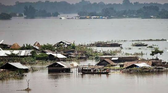
Assam continues to grapple with severe flooding in the 2026 monsoon season. Official figures released in early August put the death toll at 98, while more than 1.55 lakh people remain affected across multiple districts. Embankment breaches, prolonged heavy rainfall in the Brahmaputra and Barak basins, and the seasonal swelling of tributaries have inundated vast stretches of farmland, villages and road networks. Relief camps are operational in the worst-hit areas, and state and central agencies are coordinating rescue, distribution of essential supplies and restoration of connectivity.
The Brahmaputra river system is inherently flood-prone. Its large catchment, high sediment load, and the combination of monsoon rains with snowmelt from the eastern Himalayas produce annual inundation. Human factors—encroachment on floodplains, inadequate or aging embankments, deforestation in upstream areas, and drainage congestion—amplify the impact. Climate trends that increase the intensity of extreme rainfall events further complicate prediction and preparedness.
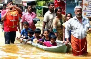
State authorities have activated the standard flood response protocol: deployment of National Disaster Response Force and State Disaster Response Force teams, evacuation from low-lying areas, provision of food, drinking water, medical care and temporary shelter, and continuous monitoring of river levels by the Central Water Commission and state water resources department. The North Eastern Space Applications Centre and other remote-sensing agencies provide satellite-based inundation maps that help prioritise relief. Despite these measures, recurring challenges include delayed restoration of power and roads, livestock losses, and the risk of water-borne diseases once the water begins to recede.
For competitive-exam aspirants the Assam floods illustrate core themes in disaster management. Questions routinely test understanding of the institutional framework (NDMA, SDMA, DDMA), the distinction between structural and non-structural measures, the role of early warning systems, and the specific vulnerabilities of the Brahmaputra valley. The annual nature of the problem raises policy issues around long-term floodplain zoning, embankment redesign, wetland conservation, and alternative livelihood strategies for flood-affected communities. Comparative analysis with floods in Bihar, Uttar Pradesh or Kerala allows candidates to discuss regional variations in monsoon behaviour and governance capacity.
The economic cost extends beyond immediate relief. Crop losses, disruption of inland transport, damage to schools and health centres, and the cumulative effect on household savings and indebtedness appear in questions on inclusive growth and rural development. The intersection with climate change adaptation and the need for resilient infrastructure links the topic to environment and sustainable development agendas.
India’s national disaster management architecture has improved significantly since the enactment of the Disaster Management Act, 2005, yet the repeated severity of Assam floods shows that structural protection alone is insufficient. Integrated approaches that combine better forecasting, community-based preparedness, ecological restoration of wetlands and stricter regulation of floodplain development remain essential. The 2026 season once again underlines the gap between annual response capacity and the deeper requirement for landscape-level resilience.
Accurate command of the latest casualty and affected-population figures, the main river systems involved, the institutional response mechanism, and the long-term policy challenges will equip aspirants to answer both factual and analytical questions on this recurring national concern.
Frequently Asked Questions
What is the current human impact of the 2026 Assam floods?
As of early August 2026 the death toll stands at 98, with more than 1.55 lakh people still affected across multiple districts.
Which river systems are primarily responsible?
The Brahmaputra and Barak river systems, together with their tributaries, driven by heavy monsoon rainfall and high sediment load.
What institutional mechanisms are involved in the response?
State and District Disaster Management Authorities, NDRF and SDRF teams, Central Water Commission monitoring, and satellite-based inundation mapping support the relief effort.
Why is this topic important for competitive exams?
It covers disaster management frameworks, structural vs non-structural measures, climate change adaptation, Brahmaputra-specific vulnerabilities, and the gap between annual relief and long-term resilience—recurring themes in GS Paper 3.
Master Disaster Management & Geography
In-depth coverage of flood management, NDMA guidelines, and climate resilient development.
Daily Current Affairs → All Exams →Join our official Telegram channel for instant updates: @rrbcontents