Home › Blog › Indian Geography › Disaster Management
Assam Flood Disaster Analysis
Disang River Flood Situation & Geographical Study
Upstream Cloudbursts, Sivasagar Crisis, Infrastructure Damage & River Basin Hydrology
By RRBCONTENTS Editorial
Published: July 23, 2026
Disang River Flood
Sivasagar Assam
NDRF Rescue
Brahmaputra South Bank
10 Min Read
Key Takeaways & Disaster Report
- Sivasagar Ground Zero: Over 3.59 lakh people across 328 villages in Sivasagar inundated after the Disang and Dikhow rivers breached historical Highest Flood Levels (HFL).
- Upstream Meteorological Trigger: Driven by massive cloudburst events in Arunachal Pradesh (+141% excess rain) and Nagaland (+181% excess rain) pouring into Patkai hill streams.
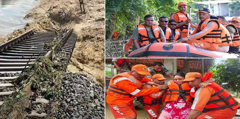
- Infrastructure Damage: Submerged NFR railway tracks between Sapekhati and Sivasagar, breached 33+ embankments/roads, and prompted Intra-Circle Roaming (ICR) telecom activation.
- Geographical Names: Called Tisa in Arunachal hills, Dilli near Namrup tea gardens, and Disang/Desang in Assam plains (253 km total length).
- Outfall & Sanctuary: Discharges into the Brahmaputra at Disangmukh near the ecologically rich Pani Dihing Bird Sanctuary.
5.65 Lakh+
People Affected in Assam
253 km
Total River Length
3,845 sq.km
Total Basin Catchment
Nanglamoraghat
HFL Breach Gauge
1. Current Flood Situation Near Disang River: Crisis Analysis
The tranquil landscapes of Upper Assam’s historical heartland—Sivasagar, Charaideo, and Dibrugarh—faced severe inundation as monsoon deluges swept through the region. Swelled beyond capacity by unprecedented cloudbursts in the upstream hills of Arunachal Pradesh and Nagaland, the Disang River (also spelled Desang) teamed up with its sister tributaries to submerge hundreds of villages, breach earthen embankments, and displace over half a million citizens.
The current surge along the Disang River basin serves as a stark reminder of the delicate ecological balance in the Brahmaputra Valley. While the river is a vital source of life, agricultural fertility, and tea plantation irrigation during dry months, its sudden, violent swelling during monsoon season presents severe hydrological and humanitarian challenges.
A. Ground Zero: Sivasagar and Surrounding Districts
The Assam State Disaster Management Authority (ASDMA) reported that the flood situation deteriorated rapidly, impacting over 5.65 lakh to 6.4 lakh people across 16 districts in Assam. Eastern Assam—specifically Sivasagar, Charaideo, Jorhat, and Dibrugarh—bore the brunt of the destruction.
- Sivasagar District Impact: Sivasagar emerged as the worst-affected district in the state. More than 3.59 lakh people across 328 villages were directly inundated by the rising waters of the Disang and Dikhow rivers.
- Human Casualties: The sudden deluge resulted in tragic loss of life, with 31 to 41 fatalities recorded across the state within a brief span. A vast majority of these deaths occurred in Sivasagar, Charaideo, and Jorhat districts due to flash flood surges and swift current drownings.
- Submerged Agricultural Land: Over 24,210 hectares of crop area—primarily wet-paddy (Sali crop) nurseries and standing crops—were submerged, creating substantial economic loss for agrarian households.
B. Hydrological Dynamics: Breaching Highest Flood Levels
The Central Water Commission (CWC) and Assam Water Resources Department gauge stations monitored critical water level spikes along the Disang River:
- Nanglamoraghat Gauge Station: The Disang River at Nanglamoraghat in Sivasagar district crossed its Danger Level and breached its historical Highest Flood Level (HFL).
- NH-37 Crossing & Gudamghat: Water levels surged past safety thresholds, causing backwater flow into low-lying agricultural drainage channels and urban peripheral drains.
- Upstream Meteorological Trigger: Chief Minister Himanta Biswa Sarma noted that the deluge was driven by extreme cloudburst events upstream. Arunachal Pradesh recorded rainfall 141% above normal, while Nagaland registered 181% above normal precipitation. This concentrated volume rushed down the steep Patkai hills directly into the Disang and Dikhow river catchments.
C. Infrastructure Damage and Emergency Disaster Response
The swelling waters destroyed civic infrastructure, isolating several rural panchayats:
- Breach of Embankments & Road Damage: Multiple earthen embankments along the Disang and its sub-tributaries suffered severe breaches. Over 33 roads and major bridges were rendered impassable or washed away.
- Railway Track Submersion: The Northeast Frontier Railway (NFR) was forced to cancel, divert, or short-terminate dozens of passenger and freight trains after floodwaters submerged railway tracks between Sapekhati, Bhojo, and Sivasagar stations.
- Emergency Communication Activation: To ensure continuous mobile connectivity in isolated areas, the Department of Telecommunications (DoT) activated Intra-Circle Roaming (ICR) across Sivasagar, Charaideo, and Jorhat districts.
- Relief Operations: Teams from the Indian Air Force (IAF), National Disaster Response Force (NDRF), State Disaster Response Force (SDRF), and Fire & Emergency Services evacuated thousands of stranded villagers using motorized inflatable boats. Over 71 relief camps and 202 relief distribution centers were set up.
2. Detailed Profile of the Disang River: Geography, Origin & Hydrology
To understand why the Disang River behaves so aggressively during the monsoon season, one must examine its origin, geographical course, catchment topology, and structural hydrology.
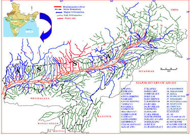
Geographical map of Assam showing the Brahmaputra River network and its major South-Bank tributaries, including the Disang, Dikhow, and Burhi Dihing.
A. Nomenclature Across Its Journey
The Disang River undergoes three distinct name changes along its course as it traverses through different geographical terrains and ethnic landscapes:
- Tisa: In its upper catchment area high in the Patkai hills of Arunachal Pradesh, the river is locally called the Tisa.
- Dilli: As the river descends into the foothills and passes through the border tea garden belts near Namrup (Assam), it is known as the Dilli River. The famous Dillighat picnic spot and tea estates derive their names from this middle reach.
- Disang (or Desang): Upon entering the broad plain stretches of Dibrugarh and Sivasagar districts, the river is universally referred to as the Disang or Desang River until its final outfall into the Brahmaputra.
B. Geographical Origin, Course, and Confluence
- Origin: The Disang River originates in the Patkai Hill Range at an elevation of approximately 2,200 meters above mean sea level in the Tirap district of Arunachal Pradesh.
- Hilly Course (Upper Stretch): The river flows in a general north-to-south and north-west direction through steep V-shaped valleys across Tirap (Arunachal Pradesh) and Mon district (Nagaland), spanning approximately 65.50 km.
- Plain Course (Lower Stretch): The river enters the Assam plains near Dilli Tea Garden in Namrup (Dibrugarh district). It then meanders through Tingkhong, Sapekhati, Sonari, Demow, and Sivasagar revenue circles across an axial plain length of 187.50 km.
- Total Length: The master Disang River has a total length of approximately 253 km (65.5 km in hills and 187.5 km in Assam plains).
- Confluence (Outfall): The river empties its discharge into the Brahmaputra River at Disangmukh (literally "mouth of the Disang") in the northern perimeter of Sivasagar district.
C. River Basin & Catchment Metrics
| Basin Parameter |
Metric / Value |
| Total Catchment Basin Area |
3,845.98 sq. km |
| Basin Area in Assam Plains/Hills |
2,009.01 sq. km (Dibrugarh & Sivasagar districts) |
| Basin Area in Arunachal & Nagaland |
1,836.97 sq. km (Tirap & Mon districts) |
| Elevation Range |
From 2,200 meters (Source) down to ~86 meters (Confluence) |
| Classification |
Major South-Bank Tributary of the Brahmaputra |
D. Major Tributaries of the Disang River
As the Disang River travels through the plains of Assam, it receives continuous flow from six major tributary streams: Timan River (Right bank), Tawkak River (Left bank), Safrai River (Left bank), Diroi River (Right bank), Dimau River, and Balama River.
3. Historical, Cultural, and Ecological Significance
The Disang River is deeply woven into the history, folklore, and biodiversity of Upper Assam.
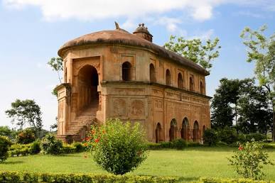
Rang Ghar in Sivasagar, the historic two-storeyed royal pavilion of the Ahom Kingdom located near the Disang and Dikhow river catchments.
A. The Heartland of the Ahom Kingdom
Sivasagar (historically known as Sibpur or Rangpur) served as the capital of the Ahom Kingdom, which ruled Assam for over 600 years (1228–1826 CE). The Disang River, along with the Dikhow and Burhi Dihing rivers, provided crucial natural defenses, inland trade routes, and fertile agricultural soil for the kingdom.
- Royal Architecture & Engineering: The Ahoms were master hydraulic engineers who constructed an intricate network of Ali (raised earthen bunds/embankments) and Pukhuri (giant man-made water tanks like Joysagar, Gaurisagar, and Sivasagar tanks) to control river overflows and maintain water security.
- Namdang Stone Bridge: Located nearby on the Namdang River (a sub-tributary), this historic bridge was carved out of a single rock in 1703 by Swargadeo Rudra Singha and continues to support modern traffic on National Highway 37 today.
B. Ecological Treasure: Pani Dihing Bird Sanctuary
Situated near the confluence of the Disang and Demow rivers on the southern bank of the Brahmaputra lies the Pani Dihing Bird Sanctuary (spanning 33.93 sq. km, declared a wildlife sanctuary in 1999). It provides habitat for over 165 recorded species of resident and migratory waterfowl, including the Spot-billed Pelican, Bar-headed Goose, Greylag Goose, White-necked Stork, and Ferruginous Duck.
4. Why Does the Disang River Flood Every Year? (5 Primary Drivers)
Flooding along the Disang River is an annual calamity caused by a combination of geological features, human intervention, and climate anomalies:
- Extreme Gradient Drop: Drops from an altitude of 2,200 meters down to less than 100 meters over just 65 km in its upper course, accelerating water down steep mountain gorges before spreading outward sideways across flat plains.
- Post-Earthquake Siltation: The catastrophic 1950 Assam-Tibet Earthquake (Magnitude 8.6) dumped millions of tons of debris into river channels. Decades of un-dredged siltation raised the riverbed, drastically reducing water-carrying capacity.
- High Meandering Index: Features sharp S-shaped loops and unstable sandy-clay banks that undergo severe lateral bank erosion during high flow.
- Brahmaputra Backwater Effect: When the main stem of the Brahmaputra flows above its danger level, it blocks Disangmukh, forcing floodwaters backward into upstream tributaries.
- Ageing Embankments & Deforestation: Earthen embankments built in the 1960s suffer breaches due to maintenance neglect, while deforestation in Patkai catchments increases surface runoff.
5. Environmental Challenge: Disang River as a Priority V Polluted Stretch
Beyond flood disasters, a 2.9 km stretch of the Disang River near Gudamghat in Dibrugarh district has been identified by the CPCB as a Priority V Polluted River Stretch under NGT directives due to untreated domestic wastewater and tea estate agricultural runoff. The Assam government has initiated plans for decentralized STPs and vegetative buffer zones along riverbanks.
6. Comparative Analysis: Major South-Bank Tributaries of Brahmaputra
| River Name |
Origin Region |
Primary Districts Covered |
Key Feature / Landmark |
Outfall Location |
| Burhi Dihing |
Patkai Hills (Arunachal) |
Tinsukia, Dibrugarh |
Passes through Dehing Patkai National Park & Digboi oil belt |
Brahmaputra at Dihingmukh |
| Disang (Desang) |
Patkai Hills (Tirap) |
Dibrugarh, Sivasagar |
Passes Dillighat, historic Ahom heartland & Pani Dihing Sanctuary |
Brahmaputra at Disangmukh |
| Dikhow |
Nagaland Hills |
Sivasagar town |
Flows through central Sivasagar town near historic Talatal Ghar |
Brahmaputra at Dikhowmukh |
| Dhansiri (South) |
Laisang Peak (Nagaland) |
Golaghat, Karbi Anglong |
Forms western boundary of Kaziranga National Park |
Brahmaputra near Numaligarh |
| Kopili |
Meghalaya Plateau |
Karbi Anglong, Hojai |
Kopili Hydroelectric Project; largest south-bank tributary |
Brahmaputra in Morigaon |
Interactive Geography & Disaster Management Quiz
Q1. Where does the Disang River originate?
A) Himalaya Range in Sikkim
B) Patkai Hill Range in Tirap District, Arunachal Pradesh
C) Mikir Hills in Karbi Anglong
D) Khasi Hills in Meghalaya
Correct Answer: B
Explanation: The Disang River originates at an elevation of 2,200 meters in the Patkai Hill Range in Tirap district, Arunachal Pradesh.
Q2. At which location does the Disang River empty its discharge into the Brahmaputra River?
A) Dihingmukh
B) Dikhowmukh
C) Disangmukh in Sivasagar District
D) Numaligarh
Correct Answer: C
Explanation: The Disang River empties into the Brahmaputra at Disangmukh in Sivasagar district.
Q3. What is the river called in its middle reach near the Namrup tea garden belt in Assam?
A) Tisa River
B) Dilli River
C) Safrai River
D) Timan River
Correct Answer: B
Explanation: As it enters the foothills near Namrup, the river is known locally as the Dilli River (giving name to Dillighat).
Q4. Which famous bird sanctuary is located near the confluence of the Disang and Demow rivers?
A) Deepor Beel Wildlife Sanctuary
B) Pani Dihing Bird Sanctuary
C) Pobitora Wildlife Sanctuary
D) Nameri National Park
Correct Answer: B
Explanation: Pani Dihing Bird Sanctuary (33.93 sq. km) is situated near the confluence of Disang and Demow rivers in Sivasagar.
Q5. Which historic single-stone bridge built in 1703 by Ahom King Rudra Singha crosses a sub-tributary in Sivasagar?
A) Saraighat Bridge
B) Kolia Bhomora Bridge
C) Namdang Stone Bridge
D) Bogibeel Bridge
Correct Answer: C
Explanation: The Namdang Stone Bridge was carved out of a single rock in 1703 under Swargadeo Rudra Singha over the Namdang River.
Frequently Asked Questions (FAQs)
Where does the Disang River originate and what are its three names along its course?
The Disang River originates at an elevation of 2,200 meters in the Patkai Hill Range in Tirap district, Arunachal Pradesh. It is known as the Tisa in its upper hilly course, the Dilli near the Namrup tea belt, and the Disang (or Desang) in the Assam plains until its outfall at Disangmukh.
Which district in Assam was worst affected by the Disang River floods in 2026?
Sivasagar emerged as the worst-affected district, with over 3.59 lakh people across 328 villages inundated by the rising waters of the Disang and Dikhow rivers.
What are the major tributaries of the Disang River?
The major tributaries of the Disang River include the Timan, Tawkak, Safrai, Diroi, Dimau, and Balama rivers.
Why does the Disang River flood frequently during monsoon season?
Annual flooding is caused by steep topographic gradient drop (from 2,200m to 100m over 65 km), post-1950 earthquake siltation raising the riverbed, backwater choking from the flooded Brahmaputra at Disangmukh, and ageing earthen embankments.
Master Indian Geography & Disaster Management Notes
Explore comprehensive river basin guides, disaster relief frameworks, and daily current affairs updates.
Solve PYQs →
Study Notes →
Join our official Telegram community for daily updates: @rrbcontents