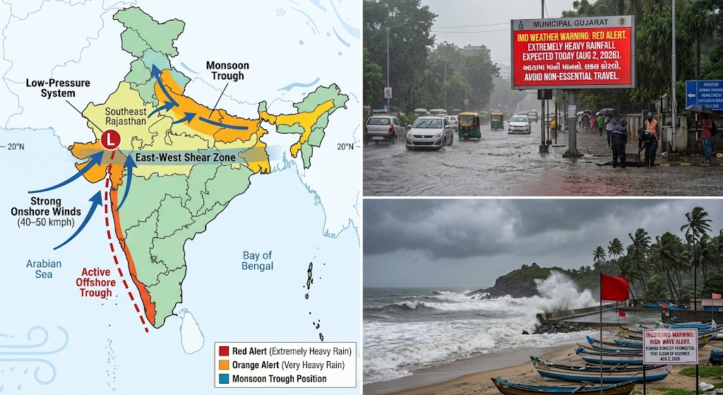
The India Meteorological Department (IMD) has issued a national weather bulletin for Sunday, August 2, 2026, keeping multiple states under heightened administrative vigil as active monsoon systems generate heavy to extremely heavy precipitation. The IMD weather forecast August 2 2026 highlights a persistent low-pressure area over Southeast Rajasthan and adjoining North Gujarat, coupled with an active offshore trough running along the Arabian Sea coastline, driving intense rainfall across Western, Southern, and Northern India.
High-alert warnings remain active across several maritime and inland states. Severe Red Alerts and high-intensity Orange Alerts have been designated across key districts in Gujarat, Kerala, Coastal Karnataka, and the Northeastern states. Meanwhile, the monsoon trough is shifting northward, intensifying rainfall activity across the Indo-Gangetic plains, Himachal Pradesh, Uttarakhand, and Delhi-NCR.
This report delivers a thorough, fact-verified breakdown of synoptic atmospheric drivers, emergency deep-dives into Red Alert districts, regional city-by-city weather profiles, hydrological and marine advisories, and public safety directives for August 2, 2026.
Section 1
Synoptic Atmospheric Drivers (August 2, 2026)
Primary Low-Pressure System: Well-marked low-pressure area over Southeast Rajasthan & North Gujarat weakening into a low-pressure corridor while pulling massive Arabian Sea moisture.
Active Offshore Trough: Extends along the mean sea level from the South Gujarat coastline down to the North Kerala maritime boundary.
East-West Shear Zone: Positioned roughly along 20°N latitude across Central and North Peninsular India, enhancing convective cloud bands.
Northward Trough Shift: Monsoon trough pulling moisture into the Indo-Gangetic plains, Himachal Pradesh, Uttarakhand, and Delhi-NCR.
A. The Rajasthan–Gujarat Low-Pressure Feedback Loop
The dominant driver for August 2 is the well-marked low-pressure area positioned over Southeast Rajasthan and adjoining North Gujarat. As this system moves slowly, it acts as an atmospheric vacuum, drawing deep tropical moisture from the East-Central Arabian Sea. This moisture flux collides with regional landmasses, triggering organized mesoscale convective systems (MCS) capable of producing short-duration rainfall rates exceeding 30 mm to 50 mm per hour.
B. The West Coast Offshore Trough and Shear Zone
Running parallel to the western littoral, an active offshore trough extends continuously from the South Gujarat coast down to the North Kerala coast. Fueled by strong southwesterly winds blowing at 40 to 50 kmph with gusts up to 60 kmph, this marine trough pushes moisture-laden air directly against the windward slopes of the Western Ghats. Concurrently, an east-west shear zone positioned along 20°N latitude consolidates rainbands over Konkan, Goa, Madhya Maharashtra, and Coastal Karnataka.
C. The Northward Shift of the Monsoon Trough
Further north, the monsoon trough is transitioning toward its near-normal position across the Indo-Gangetic plains. The interaction between easterly winds from the Bay of Bengal and low-level southwesterly winds from the Arabian Sea is expanding rainfall coverage across Punjab, Haryana, Delhi-NCR, Uttar Pradesh, Himachal Pradesh, and Uttarakhand.
Section 2
Emergency Focus: Gujarat Red Alert & Regional Flood Assessment
Gujarat remains a primary focus of national weather monitoring on August 2, 2026. Following days of incessant downpours, the IMD has maintained Red Warnings for several districts, warning of thunderstorms, lightning, gusty surface winds reaching 60 kmph, and extremely heavy rainfall exceeding 15 mm to 20 mm per hour in localized bursts.
| Parameter | Official Status / Metrics |
|---|---|
| Primary Warning Designation | RED ALERT / ORANGE ALERT |
| Key Red Warning Districts | Ahmedabad, Anand, Aravalli, Bharuch, Bhavnagar, Botad, Gandhinagar, Kutch, Kheda, Mehsana, Morbi, Patan, Sabar Kantha, Surendranagar, Vadodara. |
| Key Orange Warning Districts | Surat, Rajkot, Jamnagar, Junagadh, Amreli, Banaskantha, Chhota Udepur, Navsari, Valsad, Devbhumi Dwarka. |
| Peak Rainfall Rates | 15 mm to 25+ mm per hour in storm cells |
| River Basins Under Watch | Sabarmati, Vishwamitri, Tapi, Aji, Narmada |
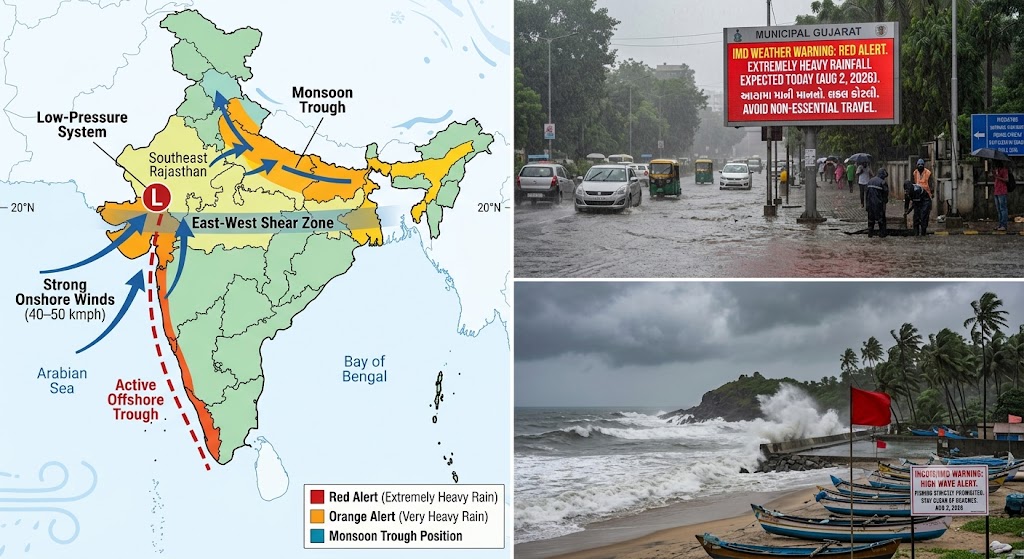
Gujarat Red Alert & Flood Assessment Visual Overview - August 2, 2026
Ahmedabad & Gandhinagar (Central Gujarat)
Metrics: Max Temp: 29.0°C | Min Temp: 24.2°C | Humidity: 88%–98% | Wind: 25-40 kmph | Expected Rain: 100-160 mm | RED ALERT
Ahmedabad and Gandhinagar face severe weather conditions on Sunday, August 2. Waterlogging is likely across low-lying underpasses (Mithakhali, Akhbarnagar, Usmanpura) and colonies in Vejalpur, Bopal, and Nikol. Sabarmati River basin inflows are under close observation.
Vadodara, Anand & Kheda (Charotar Belt)
Metrics: Max Temp: 28.5°C | Min Temp: 23.8°C | Humidity: 90%–98% | Wind: 22-38 kmph | Expected Rain: 120-180 mm | RED ALERT
Civic authorities in Vadodara are on high alert due to rising water levels in the Vishwamitri River. Low-lying areas in Sayajigunj, Fatehgunj, and Karelibaug face inundation risks.
Surat, Navsari & Valsad (South Gujarat)
Metrics: Max Temp: 28.0°C | Min Temp: 23.5°C | Humidity: 92%–98% | Wind: 35-50 kmph (gusts 65 kmph) | Expected Rain: 110-190 mm | ORANGE ALERT
Onshore winds off the Gulf of Khambhat will drive continuous rainbands inland, impacting Surat (Limbayat, Udhna, Varachha). Ukai Dam discharge is being monitored.
Section 3
Emergency Focus: Kerala & Mahe Rain Emergency & Coastal Warnings
Kerala continues to face significant weather impacts on August 2, 2026. Following extremely heavy rainfall on August 1 that resulted in tragic drownings in Malappuram and Kottayam, the IMD has transitioned early Red Warnings into a Widespread Orange Alert for 12 districts, while maintaining heavy rainfall and high wave alerts.
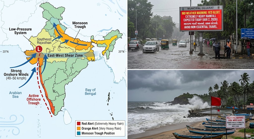
Kerala District Warning Map & Marine High Wave Alert Overview
High Range & Southern Belt (Idukki, Pathanamthitta, Kottayam)
Saturated hill slopes along the Western Ghats carry heightened risks of landslides and mudslides. Water levels in the Pamba, Manimala, and Meenachil rivers remain high. Night travel across Munnar-Gappu and Peerade corridors has been restricted.
Central Kerala (Ernakulam, Thrissur, Palakkad)
In Kochi urban agglomeration, high tides combined with continuous rain passes pose waterlogging risks in MG Road, West Kochi, and Kalamassery. Periyar and Chalakudy catchments are on flood watch.
Malabar Belt (Kozhikode, Wayanad, Kannur, Kasaragod)
Runoff from the Wayanad hills keeps streams feeding the Chaliyar and Kabini rivers swollen. INCOIS has issued a High Wave Alert (2.9m to 3.1m swells) for Kannur and Kasaragod coastlines.
Section 9
Master National City-Wise Weather Data Matrix (August 2, 2026)
Consolidated forecast metrics across 25 major Indian cities for Sunday, August 2, 2026:
| City Name | State / UT | Max Temp | Min Temp | Expected Rain | Humidity | Wind Speed | IMD Alert Code |
|---|---|---|---|---|---|---|---|
| Ahmedabad | Gujarat | 29.0°C | 24.2°C | 100 – 160 mm | 88–98% | 40 kmph | RED ALERT |
| Vadodara | Gujarat | 28.5°C | 23.8°C | 120 – 180 mm | 90–98% | 38 kmph | RED ALERT |
| Surat | Gujarat | 28.0°C | 23.5°C | 110 – 190 mm | 92–98% | 50 kmph | Orange Alert |
| Rajkot | Gujarat | 28.2°C | 24.0°C | 100 – 170 mm | 90–98% | 45 kmph | Orange Alert |
| Bhuj (Kutch) | Gujarat | 29.5°C | 24.8°C | 90 – 150 mm | 85–95% | 42 kmph | RED ALERT |
| Mumbai | Maharashtra | 28.5°C | 24.2°C | 80 – 140 mm | 88–96% | 52 kmph | Orange Alert |
| Pune | Maharashtra | 25.5°C | 21.0°C | 35 mm (150+ Ghats) | 86–95% | 32 kmph | Orange (Ghats) |
| Panaji | Goa | 27.8°C | 23.5°C | 100 – 160 mm | 90–98% | 45 kmph | Orange Alert |
| Kochi | Kerala | 28.0°C | 23.2°C | 110 – 180 mm | 90–98% | 40 kmph | Orange Alert |
| Thiruvananthapuram | Kerala | 28.8°C | 23.8°C | 40 – 80 mm | 85–95% | 35 kmph | Yellow Watch |
| Mangaluru | Karnataka | 27.2°C | 23.0°C | 120 – 190 mm | 90–98% | 50 kmph | Very Heavy Rain |
| Bengaluru | Karnataka | 26.5°C | 19.8°C | 10 – 25 mm | 76–88% | 28 kmph | Yellow Watch |
| Chennai | Tamil Nadu | 35.5°C | 27.2°C | 5 – 15 mm | 58–72% | 20 kmph | Green Watch |
| Hyderabad | Telangana | 29.2°C | 23.0°C | 20 – 45 mm | 78–90% | 35 kmph | Yellow Watch |
| Delhi-NCR | Delhi UT | 33.2°C | 26.0°C | 30 – 65 mm | 76–92% | 20 kmph | Heavy Rain Alert |
| Lucknow | Uttar Pradesh | 32.2°C | 25.8°C | 40 – 80 mm | 80–94% | 18 kmph | Heavy Rain Alert |
| Jaipur | Rajasthan | 32.5°C | 24.0°C | 35 – 65 mm | 78–94% | 30 kmph | Yellow Watch |
| Udaipur | Rajasthan | 28.0°C | 23.5°C | 80 – 140 mm | 85–96% | 32 kmph | Orange Alert |
| Dehradun | Uttarakhand | 27.8°C | 21.2°C | 80 – 150 mm | 88–98% | 15 kmph | Heavy Rain Alert |
| Shimla | Himachal Pradesh | 22.5°C | 16.0°C | 55 – 100 mm | 86–98% | 14 kmph | Heavy Rain Alert |
| Chandigarh | Punjab/Haryana | 31.8°C | 25.0°C | 35 – 70 mm | 80–94% | 18 kmph | Heavy Rain Alert |
| Kolkata | West Bengal | 31.8°C | 26.2°C | 30 – 60 mm | 84–95% | 22 kmph | Yellow Watch |
| Patna | Bihar | 32.5°C | 26.0°C | 30 – 65 mm | 80–92% | 18 kmph | Heavy Rain Alert |
| Guwahati | Assam | 30.0°C | 24.8°C | 40 – 80 mm | 85–98% | 15 kmph | Yellow Watch |
| Agartala | Tripura | 27.0°C | 22.5°C | 110 – 180 mm | 88–98% | 20 kmph | Very Heavy Rain |
What You Need to Know (Key Takeaways)
Gujarat Red Alert: Low-pressure system over SE Rajasthan/North Gujarat maintains Red Warnings across 15 districts (Ahmedabad, Vadodara, Gandhinagar, Kutch, Anand, Kheda), with rainfall exceeding 15-25 mm/hr.
Kerala Orange Alert: 12 districts remain under Orange Alert on August 2, with squalls up to 60 kmph and INCOIS High Wave warnings (2.9m–3.4m).
Heavy Rain Shifts North: Monsoon trough shifts northward expanding heavy showers over Delhi-NCR, Punjab, Haryana, UP, Uttarakhand, and Himachal Pradesh.
Marine & Fishing Ban: Strict fishing bans active across Arabian Sea coastlines from Gujarat down to Kerala due to 40-50 kmph squalls gusting to 60 kmph.
Stay Alert & Informed with RRBCONTENTS
Get live weather updates, daily current affairs, and free exam study notes delivered to your feed.
Join Telegram Channel (@rrbcontents) →Explore More