1. Key Overview and Primary Developments
│ SYNOPTIC METEOROLOGICAL SETUP (AUGUST 8, 2026) │
├────────────────────────────────────────────────────────────────────────┤
│ • Primary Monsoon Trough Axis: Extends across Central and East India, │
│ drawing deep moisture from the Bay of Bengal & East Arabian Sea. │
│ │ │
│ ▼ │
│ • East Rajasthan Cyclonic Circulation: Mid-level vortex driving │
│ intense convective precipitation over East & West Rajasthan. │
│ │ │
│ ▼ │
│ • Odisha & Bay of Bengal System: Upper-air circulation over NW Bay │
│ concentrating heavy to very heavy rainfall across Odisha & Jharkhand.│
│ │ │
│ ▼ │
│ • Lower-Tropospheric Westerly Jet: Strong winds (40–50 km/h, gusting │
│ to 60 km/h) impinging along the West Coast (Konkan to Kerala). │
└────────────────────────────────────────────────────────────────────────┘
1. Synoptic Atmospheric Dynamics: August 8, 2026
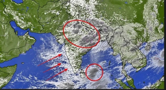
The Southwest Monsoon system across the Indian subcontinent on Saturday, August 8, 2026, is governed by an active multi-system interaction connecting Bay of Bengal low-pressure circulations, an East Rajasthan upper-air vortex, and strong Arabian Sea lower-tropospheric wind streams: [ Multi-Vortex Low-Pressure Convergence ]
│
▼
[ Strong Onshore Arabian Sea & Bay of Bengal Moisture Inflow ]
│
▼
[ Intersecting Offshore Trough along West Coast (GJ to KL) ]
│
▼
┌─────────────────────────────────┴─────────────────────────────────┐
▼ ▼
[ Orographic Slope Uplift ] [ Plains Moisture Convergence ]
(Western Ghats & Himalayan Foothills) (UP, Bihar, MP, Odisha & NE States)
A. East Rajasthan & Central Indian Circulation
A well-marked upper-air cyclonic circulation positioned over East Rajasthan and adjoining Madhya Pradesh acts as a primary rain producer for Western and Central India on August 8. This vortex draws warm, moist air from the Arabian Sea, resulting in organized mesoscale convective complexes that deliver continuous heavy to very heavy rainfall across Kota, Udaipur, Jaipur, and surrounding districts.B. Northwest Bay of Bengal & Odisha Circulation
IMD Weather Forecast August 8, 2026: Rain Alerts & State Guide
Detailed IMD weather forecast for August 8, 2026 across India. Features high-risk alert deep dives, coastal INCOIS wave ...
Meteorology & Disaster · Official Visual Reporting
2. Statutory Provisions and Official Statements
Over Eastern India, a cyclonic circulation over the Northwest Bay of Bengal off the north Odisha and Gangetic West Bengal coasts pulls deep southeasterly moisture streams inland. This system fuels intense rainfall across Odisha, Jharkhand, Gangetic West Bengal, and Chhattisgarh, maintaining high river discharges in the Mahanadi and Subarnarekha basins.C. The Arabian Sea Westerly Jet & Offshore Trough
Parallel to the western littoral, an active offshore trough extends along mean sea level from South Gujarat down to the North Kerala coastline. Driven by strong lower-tropospheric westerly winds blowing at 40 to 50 km/h with gusts reaching 60 km/h, this marine jet drives thick rainbands directly against the windward slopes of the Western Ghats, generating heavy spells across Konkan, Goa, Coastal Karnataka, and Kerala.2. Emergency High-Alert Deep Dives: Heavy Rain & Flash Flood Hazards
A critical priority for August 8, 2026, is monitoring high-vulnerability alert zones where saturated ground conditions, swelling river catchments, and steep-slope topography create significant hazards.┌────────────────────────────────────────────────────────────────────────┐
│ HIGH-ALERT REGIONAL WARNING MAP (AUG 8) │
├───────────────────────────────┬────────────────────────────────────────┤
│ Warning Category │ Affected States & Key High-Risk Zones │
├───────────────────────────────┼────────────────────────────────────────┤
│ **VERY HEAVY RAIN WARNING** │ • East Rajasthan (Kota, Udaipur, Baran)│
│ (Orange Alert Window: │ • Odisha (Mayurbhanj, Keonjhar, Puri) │
│ 12 cm to 20 cm in 24 hours) │ • Coastal Karnataka (Isolated Spots) │
├───────────────────────────────┼────────────────────────────────────────┤
│ **HEAVY RAIN & LIGHTNING │ • Kerala & Mahe (Isolated Heavy Spells)│
│ ALERT** │ • South Interior & North Interior KA │
│ (Yellow Alert Watch: │ • Uttarakhand & Himachal Pradesh │
│ 7 cm to 11 cm in 24 hours) │ • East UP, Bihar & Jharkhand │
│ │ • Assam, Meghalaya & Arunachal Pradesh │
└───────────────────────────────┴────────────────────────────────────────┘
On Saturday, August 8, the IMD has designated Orange Alerts for Heavy to Very Heavy Rainfall (12 cm to 20 cm in 24 hours) over East Rajasthan and Odisha.
East Rajasthan (Kota, Baran, Jhalawar, Udaipur): Driven by the mid-level cyclonic vortex, heavy to very heavy rainfall is forecasted across south and eastern Rajasthan. Urban centers face temporary localized waterlogging, while rural stream channels (nallahs) may experience flash runoff.
Odisha (Mayurbhanj, Keonjhar, Balasore, Bhadrak, Puri): Inward moisture convergence from the Bay of Bengal circulation is producing intense downpours accompanied by frequent cloud-to-ground lightning (vajrapat). District administrations have placed emergency response teams on standby along low-lying river corridors.
B. Kerala, Coastal Karnataka & INCOIS Kallakkadal Swell Surge Watch
Across South Peninsular India, active monsoon conditions prevail on August 8, backed by oceanographic warnings along the maritime boundary:Kerala & Mahe Rainfall Profile: Heavy rainfall (7 cm to 11 cm in 24 hours) is expected at isolated places across Kerala on August 8. Following days of intense downpours that displaced thousands of residents into relief camps earlier in the week, rivers across Central and Northern Kerala remain at high water levels.INCOIS Kallakkadal (Swell Surge) Warning: The Indian National Centre for Ocean Information Services (INCOIS) has issued a specialized Kallakkadal / Swell Surge Alert along the coastlines of Thiruvananthapuram, Kollam, and Alappuzha. Swell surge waves measuring 1.1 to 1.5 meters with peak wave periods of 16 to 20 seconds are forecast, raising risks of coastal inundation and beach erosion.Fishermen Advisory & Beach Restrictions: Authorities have advised fisherfolk, tourists, and coastal residents to avoid all beach-related activities, water sports, and sea departures until warnings are withdrawn due to squally winds gusting up to 60 km/h. August 8: Swell Surge Waves (1.1m – 1.5m) along Thiruvananthapuram Coast
│
▼
Kallakkadal Coastal Inundation Watch (Thiruvananthapuram, Kollam, Alappuzha)
│
▼
Total Ban on Sea Departures & Beach Tourism Activities
│
▼
High River Water Discharges in Periyar, Pamba & Chaliyar Basins
C. Western Himalayas: Himachal Pradesh, Uttarakhand & Jammu-Kashmir
The interaction of monsoonal moisture with mid-level circulations maintains an Orange and Yellow Alert watch across the Western Himalayas on August 8:Uttarakhand: Dehradun, Uttarkashi, Chamoli, Rudraprayag, Pithoragarh, and Nainital are under a Heavy Rainfall Watch (7 cm to 11 cm). Saturated soil profiles elevate flash flood risks along watersheds feeding the Alaknanda, Bhagirathi, and Mandakini rivers. Landslides remain likely along National Highway 58 (Rishikesh-Badrinath) and National Highway 109 (Rudraprayag-Kedarnath).Himachal Pradesh: Kangra, Kullu, Mandi, Shimla, and Sirmaur are under a Heavy Rainfall Alert. Mudslides and rockfalls present driving hazards along the Kalka-Shimla highway (NH-5).Jammu & Kashmir: Fairly widespread rainfall with isolated heavy spells is likely across Jammu, Udhampur, and Kathua districts on August 8.D. Gangetic Plains: East Uttar Pradesh, Bihar & Jharkhand Lightning Alerts
Inward moisture convergence from the Bay of Bengal is maintaining active convective storms over the plains of East Uttar Pradesh, Bihar, and Jharkhand.East Uttar Pradesh: A Heavy Rain & Lightning Alert covers Lucknow, Ayodhya, Barabanki, Gonda, Bahraich, Gorakhpur, Varanasi, and Prayagraj. Cloud-to-ground lightning (vajrapat) presents hazards in rural agricultural zones.Bihar & Jharkhand: Districts including Gopalganj, Siwan, Kishanganj, Supaul, Ranchi, and Jamshedpur are under a Heavy Rain Watch. Outdoor workers are advised to take shelter during afternoon convective formations.3. Comprehensive State-by-State Regional Forecast: August 8, 2026
3. Socio-Economic & Strategic Implications
┌────────────────────────────────────────────────────────────────────────┐
│ REGIONAL METEOROLOGICAL SUMMARY MATRIX │
├───────────────────────────────┼────────────────────────────────────────┤
│ Geographic Zone │ Summary of Expected Weather Conditions │
├───────────────────────────────┼────────────────────────────────────────┤
│ **Northwest India** │ Fairly widespread rain in J&K, HP, │
│ │ Uttarakhand, Haryana, Delhi, East & │
│ │ West Rajasthan; heavy in East Raj & HP.│
├───────────────────────────────┼────────────────────────────────────────┤
│ **Central India** │ Fairly widespread rain in East MP, │
│ │ Vidarbha & Chhattisgarh; heavy in │
│ │ East MP & Chhattisgarh; gusty winds. │
├───────────────────────────────┼────────────────────────────────────────┤
│ **West India** │ Widespread rain in Konkan & Goa; │
│ │ scattered in Madhya Maharashtra & │
│ │ Marathwada; heavy in Konkan. │
├───────────────────────────────┼────────────────────────────────────────┤
│ **East & Northeast India** │ Very heavy rain in Odisha; heavy in │
│ │ Sub-Himalayan WB, Gangetic WB, │
│ │ Jharkhand, Assam, Meghalaya, NE states.│
├───────────────────────────────┼────────────────────────────────────────┤
│ **South Peninsular India** │ Fairly widespread rain in Coastal KA, │
│ │ Kerala & Mahe, Lakshadweep; heavy in │
│ │ Coastal & South Interior KA, Kerala. │
└───────────────────────────────┴────────────────────────────────────────┘
Northwest India (Delhi-NCR, UP, Punjab, Haryana, HP, UK, J&K, Rajasthan)A. Delhi-NCR (Delhi, Noida, Gurugram, Faridabad, Ghaziabad)Maximum Temperature: 33.0°C | Minimum Temperature: 25.5°CRelative Humidity: 75% – 88% | Wind Speed: 15 to 28 km/h (Southeasterly/Westerly)Expected 24-Hour Rainfall: 20 mm to 45 mm (Fairly widespread light to moderate, isolated heavy)IMD Alert Status: Yellow AlertDetailed Outlook: Delhi-NCR will experience a generally cloudy sky on Saturday, August 8. Fairly widespread light to moderate rainfall accompanied by isolated thunder and lightning is expected during afternoon and late evening hours. High relative humidity will keep real-feel temperatures near 38°C during dry intervals. Localized waterlogging in low-lying transit corridors (Minto Bridge, Zakhira underpass, Delhi-Gurugram Expressway) may cause minor traffic slowdowns.B. Uttar Pradesh (East & West UP Belts)Maximum Temperature: 33.5°C (Lucknow) | Minimum Temperature: 26.8°CExpected 24-Hour Rainfall: 35 mm to 80 mm (Heavy Rain at isolated places)IMD Alert Status: Yellow Alert (East UP & West UP)Detailed Outlook: Fairly widespread rainfall is forecasted across Uttar Pradesh on August 8. Heavy downpours accompanied by thunderstorms and lightning are predicted across Lucknow, Sitapur, Hardoi, Ayodhya, Gonda, Bahraich, Bareilly, Moradabad, Varanasi, and Prayagraj. Low-lying agricultural fields in the Gangetic plains face temporary standing water buildup.C. Himachal Pradesh, Uttarakhand & Jammu-KashmirMaximum Temperature: 22.5°C (Shimla) / 27.5°C (Dehradun) | Minimum Temperature: 17.0°CExpected 24-Hour Rainfall: 65 mm to 130 mm (Heavy to Very Heavy Rain)IMD Alert Status: Yellow / Orange AlertDetailed Outlook: Widespread rainfall is expected across Himachal Pradesh, Uttarakhand, and Jammu & Kashmir on August 8. Isolated heavy falls are likely over Kangra, Mandi, Kullu, Shimla, Dehradun, Uttarkashi, and Nainital. Landslide risks remain high along mountain highway networks.D. Punjab, Haryana & ChandigarhMaximum Temperature: 32.5°C | Minimum Temperature: 25.2°CExpected 24-Hour Rainfall: 20 mm to 55 mmIMD Alert Status: Yellow AlertDetailed Outlook: Fairly widespread rainfall is expected across Punjab, Haryana, and Chandigarh on August 8. Gusty surface winds of 30 to 40 km/h accompanied by isolated lightning strikes are predicted.E. Rajasthan (East & West Rajasthan)Maximum Temperature: 32.0°C (Jaipur) | Minimum Temperature: 25.8°CExpected 24-Hour Rainfall: 40 mm to 120 mm (Very Heavy in East Raj)IMD Alert Status: Orange Alert (East Rajasthan) / Yellow Alert (West Rajasthan)Detailed Outlook: Overcast conditions with periodic rain spells will prevail across Rajasthan on August 8. Heavy to very heavy rainfall is likely at isolated places over East Rajasthan (Kota, Baran, Jhalawar, Udaipur), while West Rajasthan will see moderate to heavy showers with gusty winds.West & Central India (Maharashtra, Gujarat, MP, Chhattisgarh)A. Maharashtra (Mumbai, Konkan, Madhya Maharashtra, Marathwada, Vidarbha)Maximum Temperature: 30.0°C (Mumbai) | Minimum Temperature: 26.2°CExpected 24-Hour Rainfall: 50 mm to 110 mm (Heavy Spells in Konkan)IMD Alert Status: Yellow Alert (Konkan, Marathwada & Vidarbha)Detailed Outlook: Active monsoon conditions will bring cloudy skies and intermittent rainfall across Konkan, Mumbai, Thane, Palghar, Raigad, Marathwada, and Vidarbha on August 8. Heavy downpours accompanied by gusty westerly winds reaching 40 to 50 km/h are expected.B. Gujarat State (Gujarat Region, Saurashtra & Kutch)Maximum Temperature: 32.5°C (Ahmedabad) | Minimum Temperature: 26.2°CExpected 24-Hour Rainfall: 15 mm to 40 mm (Light to Moderate, isolated thunder)IMD Alert Status: Yellow WatchDetailed Outlook: Gujarat will see a mix of cloudy skies and passing showers on August 8. Light to moderate rain with isolated thunderstorms and lightning is expected, particularly in southern coastal districts.C. Madhya Pradesh & ChhattisgarhMaximum Temperature: 31.0°C (Bhopal) | Minimum Temperature: 23.8°CExpected 24-Hour Rainfall: 50 mm to 110 mm (Heavy in East MP & CG)IMD Alert Status: Yellow Alert (East MP, West MP & Chhattisgarh)Detailed Outlook: Central India will witness fairly widespread rainfall on August 8. Heavy rainfall accompanied by thunderstorms, lightning, and gusty winds (30–40 km/h) is forecasted over East Madhya Pradesh and Chhattisgarh, while West MP will see scattered showers.East & Northeast India (Bihar, Jharkhand, Odisha, W. Bengal, Assam, NE)A. Bihar & JharkhandMaximum Temperature: 33.2°C (Patna) / 30.2°C (Ranchi) | Minimum Temperature: 24.8°CExpected 24-Hour Rainfall: 40 mm to 90 mm (Heavy Rain)IMD Alert Status: Yellow Alert (Jharkhand & Bihar)Detailed Outlook: Moderate to intense lightning activity (vajrapat) is predicted over Bihar and Jharkhand on August 8. Fairly widespread rainfall with isolated heavy spells will affect Ranchi, Jamshedpur, Patna, and northern Bihar districts.B. Odisha & Gangetic West BengalMaximum Temperature: 33.0°C (Kolkata) | Minimum Temperature: 26.5°CExpected 24-Hour Rainfall: 60 mm to 140 mm (Very Heavy in Odisha)IMD Alert Status: Orange Alert (Odisha) / Yellow Alert (Gangetic WB & SHWB)Detailed Outlook: Influenced by the upper air cyclonic circulation off the north Odisha coast, Odisha will experience widespread heavy to very heavy rainfall on August 8. Thunderstorms, lightning, and gusty winds (30–40 km/h) are expected across coastal and northern districts. Gangetic West Bengal and Sub-Himalayan WB & Sikkim will see widespread heavy showers.C. Sub-Himalayan West Bengal, Sikkim & Northeastern StatesMaximum Temperature: 29.8°C (Guwahati) | Minimum Temperature: 24.8°CExpected 24-Hour Rainfall: 50 mm to 110 mm (Heavy Rain)IMD Alert Status: Yellow AlertDetailed Outlook: Assam, Meghalaya, Arunachal Pradesh, Nagaland, Manipur, Mizoram, and Tripura face active rainfall spells on August 8. Isolated heavy rainfall is forecasted across Sub-Himalayan West Bengal & Sikkim and the Northeastern states. River levels across the Brahmaputra and Barak basins remain under watch.South Peninsular India & Islands (Kerala, KA, TN, AP, TS, Lakshadweep, A&N)A. Kerala & MaheMaximum Temperature: 28.5°C | Minimum Temperature: 24.0°CExpected 24-Hour Rainfall: 70 mm to 110 mm (Isolated Heavy Rain)IMD Alert Status: Yellow Alert (Heavy Rain & Strong Surface Winds)Detailed Outlook: Rain or thundershowers will occur at most places in Kerala on August 8. Heavy rainfall (7 cm to 11 cm in 24 hours) is very likely at isolated places across the state. Strong surface winds with speeds occasionally reaching 40–50 km/h will prevail over Kerala, Lakshadweep, and Mahe.B. Coastal & Interior KarnatakaMaximum Temperature: 27.5°C (Mangaluru) / 26.5°C (Bengaluru) | Minimum Temperature: 20.0°CExpected 24-Hour Rainfall: 80 mm to 150 mm (Coastal KA & South Int KA)IMD Alert Status: Yellow / Orange Alert (Coastal & South Interior KA)Detailed Outlook: Isolated heavy to very heavy rainfall is likely over Coastal Karnataka and South Interior Karnataka on August 8. Strong surface winds gusting to 60 km/h are predicted along the coastline.C. Tamil Nadu, Andhra Pradesh & TelanganaMaximum Temperature: 37.5°C (Chennai) | Minimum Temperature: 28.0°CExpected 24-Hour Rainfall: 10 mm to 35 mm (Coastal AP & Telangana)IMD Alert Status: Yellow WatchDetailed Outlook: Isolated heavy rainfall is likely over Coastal Andhra Pradesh & Yanam on August 8. Telangana, Rayalaseema, and Tamil Nadu will see scattered light to moderate rainfall with strong surface winds.D. Lakshadweep Archipelago & Andaman IslandsMaximum Temperature: 29.0°C (Kavaratti) | Minimum Temperature: 25.0°CExpected 24-Hour Rainfall: 40 mm to 80 mmIMD Alert Status: Yellow Alert & High Wave WarningDetailed Outlook: Rain or thundershowers will occur at most places in Lakshadweep. Strong surface winds of 40–50 km/h gusting to 60 km/h will prevail. In Andaman & Nicobar Islands, isolated thundersqualls with wind speeds reaching 50–60 km/h are forecasted.4. INCOIS Coastal, Marine & High Wave Surge Warnings (Kallakkadal)The Indian National Centre for Ocean Information Services (INCOIS) and IMD have issued marine alerts for August 8, 2026:┌────────────────────────────────────────────────────────────────────────┐
│ INCOIS MARINE & COASTAL WARNINGS (AUG 8) │
├───────────────────────────────┼────────────────────────────────────────┤
│ Maritime Sector │ Official INCOIS / IMD Warning Metrics │
├───────────────────────────────┼────────────────────────────────────────┤
│ **Thiruvananthapuram, Kerala**│ **Kallakkadal Swell Surge Alert:** │
│ (Kappil To Pozhiyoor) │ Swell waves 1.1m to 1.5m (16–20 sec). │
├───────────────────────────────┼────────────────────────────────────────┤
│ **Alappuzha & Kollam Coast** │ **Kallakkadal Swell Surge Alert:** │
│ (Chellanum To AzheekalJetty) │ Swell waves 1.1m to 1.4m (16–20 sec). │
├───────────────────────────────┼────────────────────────────────────────┤
│ **Fishermen Advisory** │ **Strict Ban:** Squally winds 45–55 │
│ (Arabian Sea & Bay Waters) │ kmph gusting to 65 kmph along coasts. │
└───────────────────────────────┴────────────────────────────────────────┘
Kerala Kallakkadal Swell Surge Alert: INCOIS forecasts swell surge waves measuring 1.1 to 1.5 meters with a peak wave period of 16.0 to 20.0 seconds off the Thiruvananthapuram, Kollam, and Alappuzha coastlines. Low-lying nearshore infrastructure faces localized seawater splash and inundation.Fishermen & Beach Tourism Restrictions: Authorities have issued an absolute prohibition on beach tourism, water sports, and sea departures off Kerala, Lakshadweep, and Coastal Karnataka due to squally winds reaching 60 km/h.5. Master National 25-City Weather Matrix (August 8, 2026)The table below consolidates forecast metrics across 25 major Indian cities for Saturday, August 8, 2026:City NameState / UTMax Temp (°C)Min Temp (°C)Expected Rain (mm)Humidity (%)Wind Speed (km/h)IMD Alert CodeDelhi-NCRDelhi UT33.0°C25.5°C20 – 45 mm75–88%28 km/hYellow AlertLucknowUttar Pradesh33.5°C26.8°C35 – 80 mm80–94%35 km/hYellow AlertPatnaBihar33.2°C27.5°C40 – 90 mm80–92%40 km/hYellow AlertMumbaiMaharashtra30.0°C26.2°C50 – 110 mm85–95%45 km/hYellow AlertBhopalMadhya Pradesh31.0°C23.8°C40 – 90 mm82–95%40 km/hYellow AlertShimlaHimachal Pradesh22.5°C17.0°C65 – 130 mm88–98%50 km/hYellow AlertDehradunUttarakhand27.5°C21.0°C75 – 140 mm88–98%45 km/hYellow AlertRanchiJharkhand30.2°C23.0°C35 – 70 mm80–92%30 km/hYellow AlertKolkataWest Bengal33.5°C26.8°C35 – 75 mm80–92%35 km/hYellow AlertJaipurRajasthan32.0°C25.8°C50 – 120 mm78–92%40 km/hOrange AlertAhmedabadGujarat32.5°C26.2°C15 – 40 mm80–92%30 km/hYellow WatchKochiKerala28.5°C24.0°C70 – 110 mm88–98%50 km/hYellow AlertKozhikodeKerala28.0°C23.8°C75 – 115 mm90–98%50 km/hYellow AlertMangaluruKarnataka27.5°C23.2°C80 – 150 mm90–98%50 km/hYellow AlertBengaluruKarnataka26.5°C20.0°C15 – 30 mm75–88%30 km/hYellow WatchChennaiTamil Nadu37.5°C28.0°C5 – 20 mm58–70%20 km/hGreen WatchHyderabadTelangana30.0°C23.0°C20 – 45 mm75–88%35 km/hYellow WatchChandigarhPunjab/Haryana32.5°C25.2°C20 – 55 mm80–92%35 km/hYellow AlertGuwahatiAssam29.8°C24.8°C50 – 110 mm85–95%25 km/hYellow AlertAgartalaTripura28.0°C23.0°C50 – 110 mm88–98%30 km/hYellow AlertNainitalUttarakhand21.0°C17.0°C75 – 140 mm90–98%40 km/hYellow AlertPuriOdisha33.0°C26.5°C60 – 140 mm82–94%40 km/hORANGE ALERTRaipurChhattisgarh30.5°C24.0°C45 – 95 mm82–95%35 km/hYellow AlertJodhpurRajasthan32.5°C26.0°C20 – 45 mm75–88%35 km/hYellow WatchKavarattiLakshadweep29.0°C25.0°C40 – 80 mm85–95%50 km/hINCOIS High Wave6. Actionable NDMA & IMD Public Safety DirectivesGiven the severe weather advisories issued for August 8, 2026, the National Disaster Management Authority (NDMA) and IMD recommend the following safety measures:┌────────────────────────────────────────────────────────────────────────┐
│ ACTIONABLE SAFETY DIRECTIVES (AUG 8) │
├───────────────────────────────┼────────────────────────────────────────┤
│ Danger Category │ Recommended Public Action │
├───────────────────────────────┼────────────────────────────────────────┤
│ High-Alert Rain Zones (East │ Avoid non-essential travel; stay │
│ Rajasthan & Odisha) │ clear of swelling streams & underpasses│
├───────────────────────────────┼────────────────────────────────────────┤
│ Kallakkadal Swell Surge Zones │ Absolute ban on beach activities, │
│ (Thiruvananthapuram, Kollam) │ water sports, & nearshore recreation. │
├───────────────────────────────┼────────────────────────────────────────┤
│ Hill Slope & Landslide Zones │ Postpone mountain travel along NH-5, │
│ (HP, Uttarakhand, J&K) │ NH-58, and NH-109 due to mudslides. │
├───────────────────────────────┼────────────────────────────────────────┤
│ Rural Lightning Hazards │ Seek shelter in sturdy buildings; avoid│
│ (Bihar, UP, Jharkhand) │ standing under open trees or poles. │
└───────────────────────────────┴────────────────────────────────────────┘
Urban Inundation Safety: In cities under Orange or Yellow alerts (Jaipur, Puri, Lucknow, Patna, Mumbai, Bhopal), do not attempt to cross flooded underpasses or low-lying roads where water depth is unknown.Kallakkadal / Swell Surge Safety: Coastal residents along Thiruvananthapuram, Kollam, and Alappuzha must avoid nearshore structures and secure fishing gear away from high-tide splash zones.Himalayan Landslide Safety: Tourists and commuters in Himachal Pradesh, Uttarakhand, and Jammu & Kashmir should monitor local district collectorate advisories before traveling through mountain highways.Lightning Protection: In rural areas across Bihar, Uttar Pradesh, and Jharkhand, farm workers should seek immediate shelter inside permanent structures when thunder is heard.Key TakeawaysNational Alert Status: Active monsoon conditions affect 26 states/UTs on Saturday, August 8, 2026.Orange Warning Belts: East Rajasthan (Kota, Udaipur) and Odisha (Mayurbhanj, Puri) face heavy to very heavy rainfall (12 cm to 20 cm).Delhi-NCR Forecast: Yellow Alert for fairly widespread light to moderate afternoon/evening showers with humid conditions and localized waterlogging risks.INCOIS Swell Surge Warning: Kallakkadal warning active for Thiruvananthapuram, Kollam, and Alappuzha with waves of 1.1m to 1.5m and a total ban on beach activities.Marine Warnings: Squally winds gusting up to 60 km/h trigger a strict fishing ban active along the Arabian Sea and Bay of Bengal coasts.Suggested Categories: Weather News / India News / IMD Bulletins / Disaster ManagementSuggested Tags: IMD weather forecast August 8 2026, India rain alert 8 August, Delhi NCR monsoon forecast, Kerala rain update August 8, Odisha orange alert rain, INCOIS Kallakkadal warning, Rajasthan weather August 8
4. Key Takeaways for Competitive Examination Aspirants
Verified Exam Reference Points
- • Official Stance: Comprehensive reporting on IMD Weather Forecast August 8, 2026: Rain Alerts & State Guide.
- • Exam Utility: Key study points for UPSC, SSC CGL, RRB NTPC, and State PSC current affairs.