Home › Blog › IMD Weather Forecast August 11, 2026: Red & Orange Alerts Issued Across 14 States
IMD Weather Forecast August 11, 2026: Red & Orange Alerts Issued Across 14 States | Comprehensive Regional Bulletin
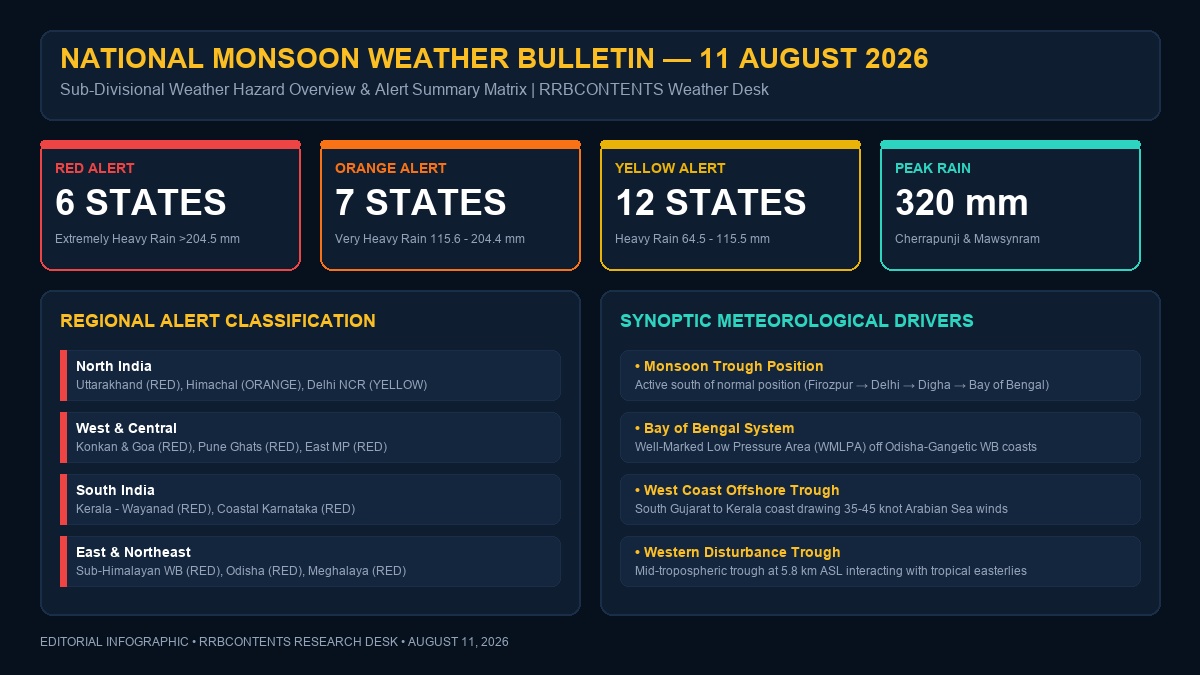
New Delhi, August 11, 2026 — The India Meteorological Department (IMD) has issued a high-priority national weather bulletin for Tuesday, August 11, 2026, placing multiple districts across fourteen states under severe Red Alert and Orange Alert warnings. Driven by an extraordinarily active South-West Monsoon architecture, a Well-Marked Low-Pressure Area (WMLPA) positioned over the Northwest Bay of Bengal, and an intense offshore trough stretching along the Arabian Sea coastline, extreme precipitation events exceeding 204.5 mm in 24 hours are forecast for fragile hill ecosystems, western coastal belts, and central river basins.
Meteorologists at IMD's National Weather Forecasting Centre (NWFC) in New Delhi report that synoptic meteorological conditions are currently displaying heightened convective instability, rapid atmospheric moisture convergence, and strong mid-tropospheric wind shear. These coupled mechanisms are producing prolonged downpours, localized cloudbursts, severe flash flooding, urban inundation, major river spates, and destructive landslides across Northern, Western, Eastern, Northeastern, and Southern India.
CRITICAL IMD NATIONAL RED ALERT ADVISORY (AUGUST 11, 2026)
Extremely Heavy Rainfall (>204.5 mm in 24 hours) is officially predicted for high-risk zones in Uttarakhand (Uttarkashi, Chamoli, Rudraprayag, Dehradun), Maharashtra (Raigad, Ratnagiri, Sindhudurg, Ghats of Pune & Satara), Kerala (Wayanad, Kozhikode, Kannur), Sub-Himalayan West Bengal (Jalpaiguri, Alipurduar, Cooch Behar), Odisha (Sambalpur, Keonjhar, Deogarh), and Meghalaya (East Khasi Hills / Cherrapunji). Residents in low-lying, riverine, and landslide-prone sectors are urged to limit movement, follow local administration alerts, and prepare for emergency evacuations.
1. Synoptic Meteorological Systems & Atmospheric Dynamics
The intensity and widespread spatial distribution of precipitation observed on August 11, 2026, are governed by five major synchronized atmospheric drivers acting simultaneously across the Indian subcontinent:
- The Active Monsoon Trough: The main sea-level monsoon trough is currently anchored south of its climatological normal position. It passes anchored coordinates through Firozpur, Rohtak, New Delhi, Kanpur, Sidhi, Jamshedpur, and Digha, before dipping southeastwards into the Northwest Bay of Bengal. This position concentrates intense low-level convergence directly over Central India, the Indo-Gangetic Plains, and the northern Bay of Bengal.
- Well-Marked Low-Pressure Area (WMLPA) over Bay of Bengal: A well-defined low-pressure system over the Northwest Bay of Bengal, off the northern Odisha and Gangetic West Bengal coasts, has intensified into a Well-Marked Low-Pressure Area. Its associated cyclonic circulation extends up to 7.6 km above mean sea level, tilting southwestward with height. This system is funneling massive volumes of tropical moisture into Odisha, West Bengal, Jharkhand, and Chhattisgarh.
- Intense West Coast Offshore Trough: A persistent sea-level offshore trough stretches uninterruptedly from the South Gujarat coast down to the Kerala coast. This trough acts as a atmospheric vacuum, drawing powerful southwesterly Arabian Sea winds blowing at 35 to 45 knots (65 to 83 km/h) directly into the Western Ghats barrier, triggering intense orographic precipitation.
- Upper-Air Cyclonic Circulation over Northwest Rajasthan: An upper-air cyclonic circulation lies over Northwest Rajasthan and adjoining Punjab between 1.5 km and 3.1 km above mean sea level, interacting with moist easterly winds from the Gangetic belt to trigger heavy localized convective activity across Northern India.
- Mid-Tropospheric Western Disturbance: A mid-tropospheric trough in westerlies with its axis at 5.8 km above mean sea level runs along Longitude 72°E, to the north of Latitude 30°N. The interaction between this mid-latitude western trough and the tropical monsoonal easterlies is creating enhanced dynamic lift over Himachal Pradesh and Uttarakhand.
| Synoptic System | Geographical Location | Altitude / Vertical Extent | Primary Impact Regions |
|---|---|---|---|
| Monsoon Trough | Firozpur to NW Bay of Bengal via Delhi & Digha | Surface to 1.5 km ASL | Indo-Gangetic Belt, North & Central India |
| Well-Marked Low Pressure (WMLPA) | Northwest Bay of Bengal (Odisha-WB Coast) | Up to 7.6 km ASL (Southwest tilt) | Odisha, West Bengal, Jharkhand, Chhattisgarh |
| Offshore Trough | South Gujarat Coast to Kerala Coast | Mean Sea Level | Konkan, Goa, Coastal Karnataka, Kerala |
| Cyclonic Circulation | Northwest Rajasthan & Adjoining Punjab | 1.5 km to 3.1 km ASL | Punjab, Haryana, Delhi NCR, East Rajasthan |
| Western Disturbance Trough | Long. 72°E, North of Lat. 30°N | 5.8 km ASL (500 hPa level) | Uttarakhand, Himachal Pradesh, Jammu & Kashmir |
2. All-India Meteorological Alert Matrix for August 11, 2026
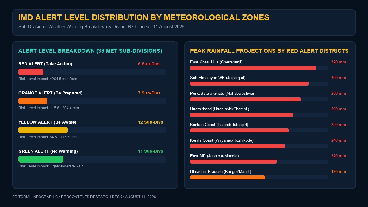
The India Meteorological Department uses a standardized four-color coding protocol to signify risk levels and required response postures. For August 11, 2026, the sub-divisional and district-level breakdown stands as follows:
| Alert Level | Warning Meaning & Action Required | Primary States Affected | Key High-Risk Districts |
|---|---|---|---|
| RED ALERT | Take Action: Extreme danger to life and infrastructure. Heavy to extremely heavy rainfall (>204.5 mm). High flood & landslide threat. | Uttarakhand, Maharashtra, Kerala, West Bengal, Odisha, Meghalaya | Uttarkashi, Chamoli, Dehradun, Raigad, Ratnagiri, Pune Ghats, Wayanad, Kozhikode, Jalpaiguri, Sambalpur, East Khasi Hills |
| ORANGE ALERT | Be Prepared: Heavy to very heavy rainfall (115.6 mm to 204.4 mm). Severe traffic, power, and waterlogging disruptions likely. | Himachal Pradesh, Madhya Pradesh, Gujarat, Karnataka, Assam, Telangana, Andhra Pradesh | Shimla, Mandi, Kangra, Jabalpur, Mandla, Mumbai, Thane, Udupi, Kodagu, Kamrup Metro, Nanded, Visakhapatnam |
| YELLOW ALERT | Be Aware: Heavy rainfall (64.5 mm to 115.5 mm) with thunderstorm, lightning, and squally winds. Localized waterlogging. | Delhi NCR, Punjab, Haryana, Uttar Pradesh, Rajasthan, Jharkhand, Bihar, Tamil Nadu | Ambala, Saharanpur, Bareilly, Jaipur, Kota, Ranchi, Patna, Nilgiris, Hyderabad, Jammu, Ramban |
| GREEN ALERT | No Warning: Light to moderate rainfall. No severe weather action required. | Parts of West Rajasthan, Rayalaseema, Interior Tamil Nadu | Jaisalmer, Barmer, Bikaner, Anantapur, Tuticorin |
3. Regional Deep-Dive: Northwest India (North Region)
Northwest India is experiencing a acute weather pulse generated by the combined interaction of monsoonal moisture currents and mid-latitude westerly dynamics. The steep topography of the Western Himalayas amplifies rainfall rates through forced orographic ascent.
Uttarakhand (Red Alert in 4 Districts)
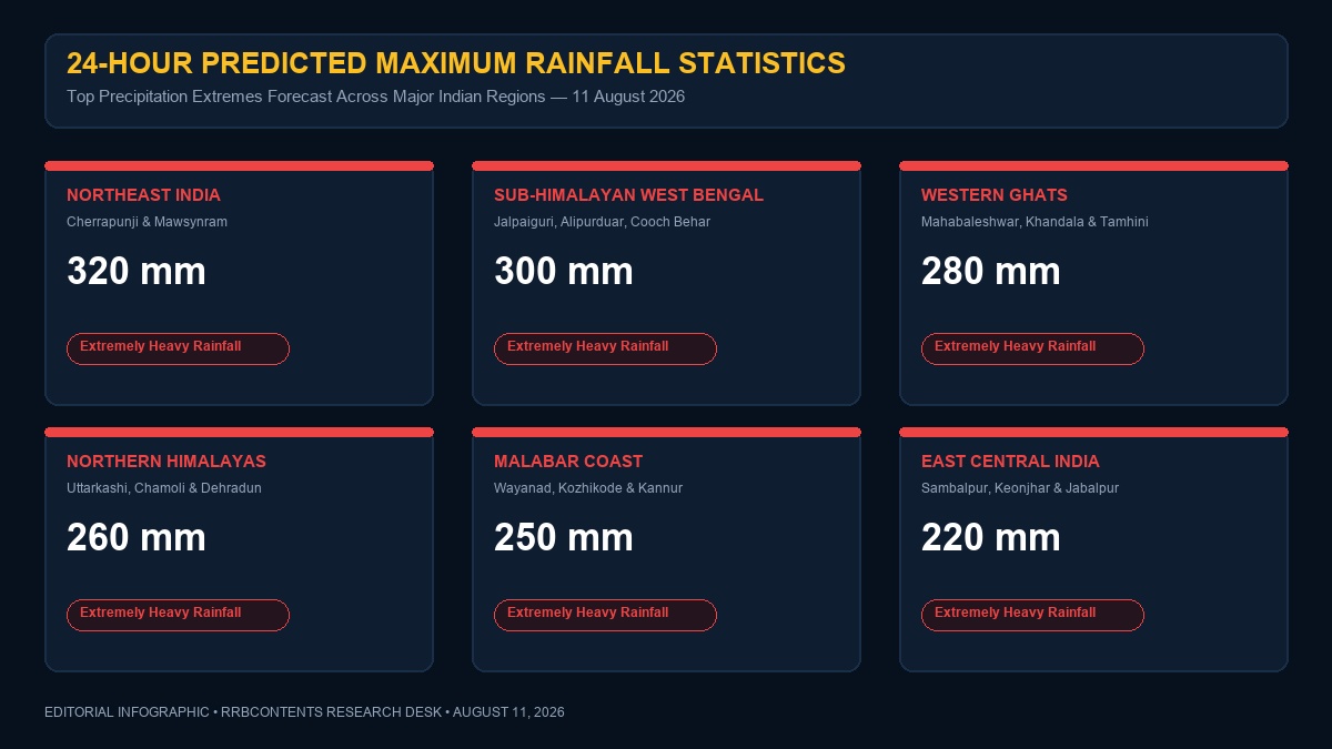
The State of Uttarakhand remains under severe stress on August 11, 2026. The IMD Regional Meteorological Centre (RMC) Dehradun has elevated warning levels to Red Alert for four major mountain and foothill districts: Uttarkashi, Chamoli, Rudraprayag, and Dehradun. Cumulative 24-hour rainfall totals in these sectors are expected to range between 210 mm and 260 mm.
- Uttarkashi District: Yamunotri Valley and Bhatwari block are experiencing severe downpours. High risk of debris flows along the Bhagirathi river basin. Expected rainfall: 220 mm.
- Chamoli District: Landslides at Helang, Birahi, and Nandaprayag have blocked the Badrinath National Highway (NH-07). Traffic movements toward Joshimath and Badrinath Dham are temporarily suspended by the district administration. Expected rainfall: 240 mm.
- Rudraprayag District: The Mandakini river is flowing near the danger mark at Sonprayag. The trek route to Kedarnath Dham has been halted at Lincholi and Bhimbali as a precautionary safety measure. Expected rainfall: 215 mm.
- Dehradun District: Dehradun city, Mussoorie, and Rishikesh are witnessing continuous intense precipitation. Rispana and Bindal rivers are heavily swollen. Doon valley total: 195 mm.
- Orange Alert Districts: Pauri Garhwal, Tehri Garhwal, Haridwar, and Nainital are under Orange Alert, expecting 130 mm to 180 mm of rain. Schools and Anganwadi centers in seven districts have been ordered closed for August 11.
Himachal Pradesh (Orange Alert in 6 Districts)
In Himachal Pradesh, an Orange Alert is active across Shimla, Mandi, Kullu, Kangra, Chamba, and Sirmaur districts. Heavy to very heavy rainfall (120 mm to 190 mm) accompanied by cloud-to-ground lightning is forecast.
The Beas River is experiencing rapid water level surges. Pandoh Dam authorities in Mandi district have opened spillway gates to release 45,000 cusecs of water, prompting flood warnings for downstream areas including Nagwain and Aut. Landslide blockades have been reported on 182 rural roads, including key stretches of the Shimla-Kalka National Highway (NH-05) near Parwanoo and the Chandigarh-Manali Highway (NH-21) near Pandoh. Dharamshala in Kangra recorded 165 mm in the preceding 12 hours.
Jammu & Kashmir and Ladakh
The Union Territory of Jammu & Kashmir is under a Yellow Alert. Heavy spell warnings are active for the Jammu division districts of Reasi, Udhampur, Kathua, and Samba. On the Jammu-Srinagar National Highway (NH-44), shooting stones and mudslides at Panthyal, Mehar, and Cafeteria Morh in Ramban district have slowed convoy traffic. In Kashmir valley, moderate rain is expected in Anantnag, Kulgam, and Srinagar. Ladakh experiences cloudy skies with isolated showers over Kargil and Leh higher passes.
Delhi NCR, Punjab, Haryana & Chandigarh
The National Capital Region (Delhi NCR) is under a Yellow Alert for August 11, 2026. Sky conditions will remain generally cloudy with moderate to heavy rain showers accompanied by gusty surface winds blowing at 30 to 40 km/h. Temperatures in Delhi are projected between a minimum of 25.4°C and a maximum of 31.2°C, with relative humidity staying near 92%.
Municipal authorities in Delhi have deployed mobile water-pumping units at vulnerable inundation hotspots including Minto Bridge underpass, Dhaula Kuan flyover, ITO intersection, Pul Prahladpur, and Zakhira flyover. In Haryana, heavy rainfall is predicted for Ambala, Yamunanagar, Panchkula, and Kurukshetra, with the Yamuna river level monitored at Hathnikund Barrage. In Punjab, Pathankot, Gurdaspur, Hoshiarpur, and Rupnagar districts expect isolated heavy falls (70 mm to 110 mm).
Uttar Pradesh & Rajasthan
Western Uttar Pradesh (Saharanpur, Muzaffarnagar, Bijnor, Moradabad, Bareilly, Rampur) is slated for heavy precipitation (90 mm to 150 mm) under the influence of the active monsoon trough. Eastern Uttar Pradesh (Gorakhpur, Ayodhya, Varanasi, Prayagraj, Ballia) will see light to moderate rain with isolated thunder spells. River levels of Ghaghara, Rapti, and Sharda are being closely tracked by the State Water Resources Department.
In East Rajasthan, an upper-air circulation will trigger heavy to very heavy rainfall across Kota, Baran, Jhalawar, Sawai Madhopur, Bundi, Jaipur, and Bhilwara districts, with expected amounts reaching 140 mm. West Rajasthan districts (Jodhpur, Barmer, Bikaner) will remain mostly dry to light-shower zones.
4. Regional Deep-Dive: West & Central India
West and Central India represent the core monsoon precipitation belt on August 11, 2026. The collision of intense southwesterly Arabian Sea winds against the steep Western Ghats escarpment produces extreme orographic rainfall.
Maharashtra (Konkan & Ghats Red Alert)
The IMD Regional Meteorological Centre (RMC) Mumbai has issued a critical Red Alert for the coastal Konkan districts of Raigad, Ratnagiri, and Sindhudurg, as well as the Ghat regions of Pune and Satara districts. 24-hour rainfall projections exceed 220 mm to 280 mm in these zones.
- Raigad District: Extreme rain forecast for Mahad, Poladpur, Mangaon, and Roha. Savitri and Amba rivers are flowing close to their respective danger marks. Expected rainfall: 250 mm.
- Ratnagiri District: Chiplun and Khed Talukas are on high alert. The Vashishti River water level is monitored around 6.8 meters (warning level 7.0 meters). Expected rainfall: 240 mm.
- Pune & Satara Ghats: Lonavala, Khandala, Tamhini Ghat, Mahabaleshwar, and Koyna catchment areas are expected to receive extreme rainfall totals between 240 mm and 290 mm. Heavy inflows into Koyna Dam and Khadakwasla Dam reservoir systems.
- Mumbai, Thane & Palghar (Orange Alert): Financial capital Mumbai, along with Thane and Palghar, is under an Orange Alert. Heavy to very heavy rainfall (120 mm to 180 mm) is expected, coinciding with a high sea tide of 4.38 meters at 14:12 IST. BMC has alerted Ward Officers and disaster management cells for potential low-lying flooding in Hindmata, Sion, Kurla, Andheri Subway, and Dadar.
- Marathwada & Vidarbha: Nanded, Latur, and Chhatrapati Sambhajinagar in Marathwada expect moderate to heavy rain. Vidarbha districts (Gadchiroli, Chandrapur, Nagpur, Bhandara, Gondia) are under Orange Alert with Wainganga and Wardha river basins receiving sustained inflows.
Gujarat State (Saurashtra & South Gujarat)
Gujarat experiences active monsoon conditions sustained by the sea-level offshore trough. An Orange Alert is active for South Gujarat districts: Navsari, Valsad, Dangs, Tapi, and Surat, with 24-hour rainfall estimates of 130 mm to 190 mm. Low-lying areas of Ambika and Purna river basins face submergence risks. Saurashtra region (Junagadh, Gir Somnath, Amreli, Bhavnagar) will receive moderate to heavy showers, while Kutch will remain relatively dry with light rain.
Madhya Pradesh & Chhattisgarh
The state of Madhya Pradesh sits directly in the path of the westerly-moving Well-Marked Low-Pressure Area. IMD Bhopal has declared a Red Alert for East Madhya Pradesh districts: Jabalpur, Katni, Mandla, Dindori, Seoni, and Chhindwara, with expected rainfall totals of 200 mm to 230 mm.
West Madhya Pradesh (Bhopal, Indore, Ujjain, Narmadapuram, Raisen, Sehore) is under an Orange Alert (110 mm to 170 mm). Spillway gates at Bargi Dam (Jabalpur) and Tawa Dam (Narmadapuram) have been opened to discharge surplus floodwaters into the Narmada River trunk channel. In Chhattisgarh, an Orange Alert spans Bastar, Sukma, Bijapur, Dantewada, Kanker, Raipur, and Bilaspur, driven by low-pressure activity over the Mahanadi upper catchment.
Hydrological Alert: Narmada & Godavari Basins
Due to simultaneous extreme rainfall in MP, Maharashtra, and Chhattisgarh, water inflows into Bargi, Indira Sagar, Ukai, and Jayakwadi reservoirs are running at 180% of normal August averages. Riverbank communities along the Narmada and Godavari rivers must maintain high vigilance.
5. Regional Deep-Dive: East & Northeast India
Driven by the Well-Marked Low-Pressure Area situated in the Bay of Bengal and strong moisture feed from the Bay, East and Northeast India face severe rain spells and hazardous mountain terrain conditions.
Odisha (Red Alert in Inland & North Districts)
IMD Meteorological Centre Bhubaneswar has placed Sambalpur, Deogarh, Keonjhar, Jharsuguda, Sundargarh, and Mayurbhanj under a Red Alert for August 11, 2026. Peak rainfall figures are forecast to reach 210 mm to 250 mm.
Coastal Odisha (Bhubaneswar, Cuttack, Puri, Jagatsinghpur, Kendrapara, Balasore) will see moderate to heavy rain accompanied by squally winds of 45 to 55 km/h gusting to 65 km/h. Port warning signals (Local Cautionary Signal No. 3) remain hoisted at Paradip, Dhamra, and Gopalpur ports due to turbulent sea state conditions.
West Bengal & Sikkim (North Bengal Red Alert)
Sub-Himalayan West Bengal is confronting an extreme rainfall spell. IMD Kolkata has issued a Red Alert for Jalpaiguri, Alipurduar, and Cooch Behar districts, where 24-hour rainfall will reach extraordinary levels of 220 mm to 300 mm. Darjeeling and Kalimpong hills are under Orange Alert (150 mm to 200 mm), with heightened risks of landslides along National Highway 10 (NH-10) connecting Siliguri to Gangtok.
Teesta, Torsa, Jaldhaka, and Mahananda rivers are flowing near flood levels. In Gangetic West Bengal, Kolkata, Howrah, Hooghly, North 24 Parganas, and South 24 Parganas will witness moderate to heavy showers (60 mm to 100 mm) with cloudy skies and high humidity.
Assam, Meghalaya & Northeastern States
The Northeastern regional meteorological hub in Guwahati reports intense monsoonal convergence over the Southern Asian mountain rim:
- Meghalaya (Red Alert): The southern slopes of Meghalaya—specifically East Khasi Hills (Cherrapunji & Mawsynram) and South Garo Hills—are under Red Alert. Cherrapunji and Mawsynram are forecast to record extreme 24-hour rainfall totals exceeding 320 mm. Severe flash flooding and slope failures threaten hill highways.
- Assam (Orange Alert): Kamrup Metropolitan (Guwahati), Barpeta, Dhubri, Goalpara, Lakhimpur, Dhemaji, Cachar, and Karimganj expect heavy to very heavy rainfall (130 mm to 210 mm). Flood warnings are active along Brahmaputra River tributaries including Kopili, Beki, and Jia Bharali.
- Arunachal Pradesh: Orange Alert for Papum Pare, West Kameng, East Siang, and Changlang. High risk of landslides along the Trans-Arunachal Highway.
- Nagaland, Manipur, Mizoram & Tripura (NMMT): Widespread moderate to heavy rain with isolated very heavy falls (90 mm to 140 mm) in Kohima, Imphal, Aizawl, and Agartala.
Bihar & Jharkhand
In Bihar, northern and eastern districts bordering Nepal and West Bengal (Kishanganj, Araria, Purnia, Supaul, Katihar) are under an Orange Alert, expecting 100 mm to 160 mm of rain due to moisture convergence against the Himalayan foothills. Kosi, Mahananda, and Bagmati river levels are rising steadily. Jharkhand (Ranchi, Jamshedpur, Dhanbad, Hazaribagh, East Singhbhum) will record heavy isolated rain spells (80 mm to 130 mm).
6. Regional Deep-Dive: South Peninsular India & Island Territories
South Peninsular India faces severe weather along its western coastline and interior mountain passes as southwesterly Arabian Sea winds crash into the Western Ghats.
Kerala & Mahe (Red Alert in 3 Northern Districts)
The IMD Meteorological Centre Thiruvananthapuram has issued a Red Alert for three northern districts: Wayanad, Kozhikode, and Kannur. Expected 24-hour precipitation totals stand at 210 mm to 250 mm.
- Wayanad District: High landslide vulnerability in Vythiri, Meppadi, and Mananthavady Talukas. Local administration has restricted night travel in hilly sectors. Total forecast: 240 mm.
- Kozhikode & Kannur: Vadakara, Koyilandy, Iritty, and Taliparamba are on high alert for riverine flooding along the Chaliyar and Valapattanam rivers.
- Orange Alert Districts: Ernakulam, Thrissur, Palakkad, Malappuram, and Kasaragod are under Orange Alert (120 mm to 180 mm). Idukki district hill ranges (Munnar, Peerumade) will see heavy downpours with water level monitoring at Banasurasagar Dam and Mullaperiyar Dam.
Karnataka (Coastal & South Interior)
Coastal Karnataka (Uttara Kannada, Udupi, and Dakshina Kannada / Mangaluru) is placed under a Red Alert, with torrential rain forecast between 220 mm and 270 mm. High sea wave alerts (3.8 to 4.9 meters) have been issued by INCOIS for the Mangaluru and Karwar coastal stretches, warning against coastal erosion.
South Interior Karnataka districts (Kodagu / Madikeri, Chikamagaluru, Shivamogga, Hassan) are under an Orange Alert (130 mm to 190 mm). Inflows into Krishna Raja Sagara (KRS) Dam and Kabini Reservoir are increasing rapidly. North Interior Karnataka (Belagavi, Dharwad, Haveri, Kalaburagi) will receive heavy localized showers.
Tamil Nadu, Puducherry & Andhra Pradesh / Telangana
In Tamil Nadu, heavy rainfall (110 mm to 160 mm) is concentrated over the Western Ghats catchment districts of Nilgiris (Ooty, Coonoor) and Coimbatore Ghats (Valparai) under an Orange Alert. Interior plains (Chennai, Madurai, Coimbatore city) will experience moderate cloudiness with isolated convective evening showers and gusty winds (30-40 km/h).
Coastal Andhra Pradesh (Visakhapatnam, Vizianagaram, Srikakulam, Kakinada) will see heavy showers driven by the Bay of Bengal low-pressure system, while Telangana (Adilabad, Nizamabad, Mancherial, Hyderabad) is under an Orange Alert for isolated heavy downpours (90 mm to 150 mm).
Island Territories (Andaman & Nicobar, Lakshadweep)
Andaman and Nicobar Islands (Port Blair, Car Nicobar) will witness widespread rain with squally winds blowing at 40 to 50 km/h gusting to 60 km/h. Lakshadweep Archipelago (Kavaratti, Agatti, Minicoy) faces rough sea conditions under the influence of the active Arabian Sea offshore trough.
7. Disaster Management, Marine Warnings & Infrastructure Impact
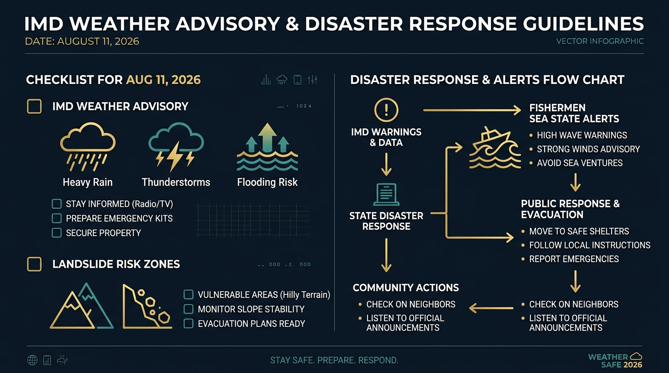
The scale of weather warnings across India on August 11, 2026, has activated multi-agency emergency operations coordinated by the National Disaster Management Authority (NDMA) and State Disaster Response Forces (SDRF).
NDRF & SDRF Deployment Matrix
A total of 84 self-contained teams of the National Disaster Response Force (NDRF) have been positioned across high-risk states on August 11, 2026. Teams are equipped with inflatable motorboats, flood rescue gear, tree-cutters, satellite communication sets, and canine search units:
| State / Region | NDRF Teams Deployed | Primary Base Locations | Key Risk Operations |
|---|---|---|---|
| Maharashtra | 14 Teams | Mumbai, Thane, Raigad, Ratnagiri, Mahad, Kolhapur | Urban flood relief, Konkan river spates, Ghat landslides |
| Uttarakhand | 12 Teams | Dehradun, Uttarkashi, Chamoli, Rudraprayag, Rishikesh | Pilgrim safety, Char Dham highway clearance, river evacuation |
| Kerala | 10 Teams | Wayanad, Kozhikode, Kannur, Idukki, Thrissur | Landslide search & rescue, hilly terrain evacuations |
| West Bengal & Sikkim | 12 Teams | Jalpaiguri, Alipurduar, Siliguri, Gangtok, Kolkata | Teesta flood watch, North Bengal landslide rescue |
| Odisha | 10 Teams | Sambalpur, Keonjhar, Jharsuguda, Balasore, Puri | Inland inundation relief, reservoir spillway alerts |
| Himachal Pradesh | 8 Teams | Mandi, Kullu, Shimla, Kangra | Beas river overflow monitoring, road blockade clearance |
| Northeastern States | 18 Teams | Guwahati, Shillong, Silchar, Agartala, Itanagar | Brahmaputra basin floods, Cherrapunji flash flood relief |
IMD Marine & Fishermen Warnings
The IMD Marine Meteorological Division has issued an absolute prohibition for maritime activities along specific sea sectors on August 11, 2026:
- Arabian Sea Coast: Fishermen are strictly advised NOT to venture into the sea along and off the coasts of Gujarat, Maharashtra, Goa, Karnataka, and Kerala. Squally wind speeds reaching 45 to 55 km/h gusting to 65 km/h, with rough to very rough sea conditions (wave heights 3.5 to 5.2 meters), will prevail over the East-Central and South-West Arabian Sea.
- Bay of Bengal Coast: Fishermen are advised NOT to venture into the North and West-Central Bay of Bengal, and along the coasts of Odisha, West Bengal, and Northern Andhra Pradesh. Squally winds reaching 45 to 55 km/h with high wave swells are expected.
Major Transportation & Highway Disruptions
Heavy rainfall and slope instability have impacted key national transport corridors on August 11, 2026:
- Char Dham Yatra Routes (Uttarakhand): Traffic on the Badrinath National Highway (NH-07) is halted at Helang and Birahi due to landslide debris. Kedarnath trek path from Gaurikund is restricted during heavy downpour intervals.
- Konkan Railway Network: Speed restrictions (40 km/h caution limit) are enforced across vulnerable bridges, tunnels, and cutting sections along the Roha-Ratnagiri-Madgaon sector due to heavy rain.
- National Highways: NH-10 (Siliguri-Gangtok), NH-05 (Shimla-Kalka), NH-21 (Chandigarh-Manali), and NH-66 (Mumbai-KanyaKumari along Konkan stretch) report precautionary diversions at localized mudslide points.
- Aviation Advisory: Flight operations at Dehradun (Jolly Grant), Mumbai (CSMIA), Bagdogra (Siliguri), and Kochi International Airports are experiencing weather-related holding patterns and minor schedule delays.
8. Agricultural Impact & Hydrological Basin Analysis
The heavy rainfall spell of August 11, 2026, carries dual implications for Indian agriculture and regional hydrology:
Kharif Crop Outlook
While the abundant rain provides vital soil moisture for standing Kharif crops (Paddy, Soybean, Maize, Cotton, Turmeric, Sugarcane), extreme downpours in Red Alert districts pose risks of crop lodging and waterlogging in low-lying fields:
- Paddy Transplatation: Favorable in Gangetic West Bengal, Bihar, UP, and Odisha. However, prolonged inundation in North Bengal and coastal Odisha may submerse freshly transplanted seedlings.
- Soybean & Pulses: Fields in East Madhya Pradesh and Vidarbha require immediate drainage measures to prevent root-rot fungal infections caused by water stagnation.
- Cotton & Groundnut: South Gujarat and East Rajasthan cotton belts require field runoff channels to clear excess rain.
Major River Basin Hydrology & Dam Water Storage
Central Water Commission (CWC) monitoring stations indicate rapid storage accumulation across major Indian river reservoirs as of August 11, 2026:
| Reservoir / Dam Name | State / River Basin | Current Water Level (Meters) | Full Reservoir Level (FRL) | Operational Status / Gate Action |
|---|---|---|---|---|
| Bargi Dam | Madhya Pradesh (Narmada Basin) | 421.15 m | 422.80 m | 11 Spillway Gates Opened (Discharging 32,000 cusecs) |
| Koyna Dam | Maharashtra (Krishna Basin) | 652.40 m | 657.90 m | Radial Gates Opened 1.5 ft (Controlled Discharge) |
| Pandoh Dam | Himachal Pradesh (Beas Basin) | 887.20 m | 896.10 m | Spillway Gates Open (Discharging 45,000 cusecs) |
| Hirakud Dam | Odisha (Mahanadi Basin) | 188.40 m | 192.02 m | 8 Sluice Gates Opened to Maintain Buffer |
| KRS Dam | Karnataka (Cauvery Basin) | 37.20 m | 38.04 m (124.8 ft) | Inflow at 48,000 cusecs; Crest Gates Monitored |
| Idukki Dam | Kerala (Periyar Basin) | 724.85 m | 732.43 m | Orange Contour Alert Level Maintained |
9. Frequently Asked Questions (FAQ) & Emergency Helpline Directory
Q: What is the exact rainfall criteria used by IMD for Red, Orange, and Yellow Alerts?
A: According to IMD standard meteorological definitions, a Red Alert indicates expected 24-hour rainfall exceeding 204.5 mm (Extremely Heavy Rainfall) requiring immediate safety action. An Orange Alert signifies expected rainfall between 115.6 mm and 204.4 mm (Very Heavy Rainfall) requiring public preparedness. A Yellow Alert signifies rainfall between 64.5 mm and 115.5 mm (Heavy Rainfall) requiring public awareness.
Q: Which major tourist and pilgrimage routes are affected by the August 11 weather forecast?
A: Travel along the Uttarakhand Char Dham circuit (Badrinath NH-07, Kedarnath trek route, Yamunotri valley), Himachal Pradesh routes (Shimla-Kalka NH-05, Chandigarh-Manali NH-21), and North Bengal-Sikkim corridors (NH-10) are experiencing severe weather delays and temporary traffic halts. Pilgrims and tourists are advised to defer non-essential travel.
Q: How can fishermen check real-time sea state and weather warnings?
A: Fishermen and coastal communities can check official real-time updates via the IMD official portal (mausam.imd.gov.in), INCOIS ocean state forecasts (incois.gov.in), or by contacting their respective State Fisheries Department emergency cells.
National & State Emergency Helpline Numbers
| Emergency Operation Service | Toll-Free Helpline Number | Operational Timing |
|---|---|---|
| National Disaster Response Force (NDRF) Control Room | 011-24363260 / 1078 | 24 Hours / 7 Days |
| National Emergency Number (All-in-One Response) | 112 | 24 Hours / 7 Days |
| IMD Weather Information Toll-Free Helpline | 1800-180-1717 | 06:00 IST to 22:00 IST |
| Uttarakhand Disaster Control Room (SEOC) | 0135-2710334 / 1070 | 24 Hours / 7 Days |
| Maharashtra State Disaster Control Room | 022-22027990 / 1070 | 24 Hours / 7 Days |
| Kerala State Disaster Management Authority (KSDMA) | 0471-2331645 / 1077 | 24 Hours / 7 Days |
| Odisha State Disaster Management Authority (OSDMA) | 0674-2534177 / 1070 | 24 Hours / 7 Days |
Stay Ahead with Real-Time National & Exam Current Affairs
Access daily comprehensive current affairs analysis, official government notifications, weather intelligence, and competitive exam updates curated by domain experts.
Daily Current Affairs Hub → Latest Jobs & Exam Results →Join our official Telegram channel for instant updates: @rrbcontents