Global power has always flowed through narrow waters. A handful of straits and canals carry a disproportionate share of the world’s oil, containers, grain and naval fleets.
Table of Contents
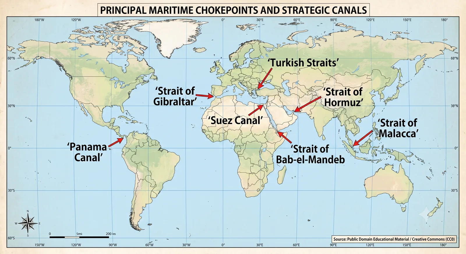
World map displaying principal maritime chokepoints and strategic canals like Panama Canal, Suez Canal, and Straits of Malacca, Hormuz, and Gibraltar.
Global power has always flowed through narrow waters. A handful of straits and canals carry a disproportionate share of the world’s oil, containers, grain and naval fleets. Control, disruption or even the threat of disruption at these points can reorder markets, force military deployments and reshape alliances. For students of geography, international relations and strategic affairs, these maritime chokepoints are not mere locations on a map; they are the pressure points of the contemporary international system.
This article examines the most important straits and canals of the world. It locates each on the map, explains the physical and political setting, and analyses the economic, military and diplomatic stakes that make them critical. Special attention is given to those waterways that directly affect India’s energy security, trade routes and naval outlook.
Boost Your UPSC Preparation
Get exclusive study material, current affairs updates, and strategic insights daily.
Join Our Telegram Channel @rrbcontents →Chapter 1
Understanding Maritime Chokepoints
A strait is a naturally formed narrow waterway connecting two larger bodies of water. A canal is an artificial channel built to create or shorten a navigable route. What turns either into a chokepoint is the combination of high traffic volume and limited alternative paths. When a large percentage of global or regional trade must pass through a single restricted passage, the power to open, close or regulate that passage becomes a strategic asset.
The vulnerability is twofold. First, physical blockage—whether by accident, conflict or deliberate action—can halt traffic. Second, the political authority that sits on the banks can impose regulations, fees, inspections or restrictions. In an age of just-in-time logistics and concentrated energy flows, even short disruptions produce global effects.
Chapter 2
Mediterranean and European Passages
The Strait of Gibraltar links the Atlantic Ocean with the Mediterranean Sea. Barely 14 kilometres wide at its narrowest, it is bounded by Spain and the British territory of Gibraltar on the north and by Morocco on the south. It remains the only natural entrance to the Mediterranean from the west. Naval powers have contested it for centuries; today it is a busy commercial route and a monitoring point for migration and military movements between Europe and North Africa.
Further east, the Turkish Straits—the Dardanelles and the Bosphorus—connect the Mediterranean with the Black Sea. The Bosphorus runs through the heart of Istanbul; the Dardanelles links the Sea of Marmara to the Aegean. Under the Montreux Convention of 1936, Turkey regulates naval passage, especially for warships of non-Black Sea powers. These straits are vital for Russian, Ukrainian and Caucasian trade and for any naval reinforcement into or out of the Black Sea. Recent conflicts have underlined their continuing sensitivity.
The Kiel Canal in Germany offers a shorter route between the North Sea and the Baltic, avoiding the long passage around Denmark. Though smaller in global volume than Suez or Panama, it remains important for European short-sea shipping and naval movement within NATO’s northern theatre.
Chapter 3
Middle Eastern and Western Indian Ocean Chokepoints
No waterway carries more concentrated strategic weight than the Strait of Hormuz. Located between Iran and the Musandam Peninsula of Oman, it connects the Persian Gulf with the Gulf of Oman and the Arabian Sea. At its narrowest the navigable channel is only a few kilometres wide. Roughly one-fifth of the world’s oil trade and a significant volume of liquefied natural gas pass through it. Iran’s repeated statements about possible closure, and the regular presence of the United States Fifth Fleet and other navies, keep the strait at the centre of energy security calculations. For India, which imports a large share of its crude from Gulf suppliers, Hormuz is a daily concern.
Further southwest, the Bab-el-Mandeb Strait links the Red Sea with the Gulf of Aden and the Indian Ocean. Bordered by Yemen on the Arabian side and by Djibouti and Eritrea on the African side, it is the southern gate to the Suez Canal route. Traffic that has already passed through Suez must still clear Bab-el-Mandeb. Instability in Yemen, piracy in the Gulf of Aden, and the presence of multiple foreign military bases in Djibouti have made this narrow passage a focus of international naval attention. Disruptions here force tankers and container ships to take the long route around the Cape of Good Hope, adding time and cost.
The Suez Canal itself is the artificial counterpart to these natural straits. Opened in 1869, it cuts through Egyptian territory to join the Mediterranean with the Red Sea. By eliminating the journey around Africa it shortened the Europe–Asia route dramatically. The canal remains one of the world’s most important commercial arteries. Its temporary blockage by the container ship Ever Given in 2021 demonstrated how a single incident can hold up global supply chains and cost billions. Egypt’s control of the canal gives it both revenue and geopolitical leverage; the canal’s security is therefore a standing interest for every major trading nation, including India.
Chapter 4
Southeast Asian Straits – The Malacca Complex
The Strait of Malacca, running between the Malay Peninsula and the Indonesian island of Sumatra, is the shortest sea route between the Indian Ocean and the Pacific. It is also one of the busiest and most congested. A large share of the oil moving from the Gulf to East Asia, together with massive container traffic between Europe, the Middle East, South Asia and East Asia, funnels through this passage. Singapore sits at its southern entrance and has built one of the world’s great entrepôt economies on the traffic.
The strait is shallow in places and requires careful navigation. Piracy and armed robbery have been recurring problems, though regional cooperation has reduced incidents in recent years. Alternative routes exist—the Sunda Strait and the Lombok Strait further east—but they are longer or less convenient for the largest vessels. China’s concern about the “Malacca Dilemma”—the fear that a hostile power could interrupt its energy imports—has driven investments in pipelines, alternative ports and naval capacity. India, as a resident power in the Indian Ocean, watches the same waters closely; the Andaman and Nicobar Command sits astride the western approaches to Malacca.
Chapter 5
The American Canal and Pacific Passages
The Panama Canal links the Atlantic and Pacific Oceans across the Isthmus of Panama. Completed in 1914, it remains critical for trade between the eastern and western seaboards of the Americas and for some Asia–US East Coast traffic. The canal’s locks limit the size of vessels (Panamax and the newer Neopanamax standards). Recent drought-related restrictions on water levels have shown that even this engineered marvel is subject to climatic stress. Control of the canal has long been a United States strategic interest; its transfer to full Panamanian ownership did not eliminate great-power attention.
In the western Pacific the Taiwan Strait separates Taiwan from mainland China. It is both an international waterway and one of the most heavily militarised zones on earth. Commercial traffic is heavy, yet any crisis across the strait would immediately threaten one of the world’s major trade lanes and would draw in the naval forces of several powers. Further north, passages through the Japanese islands and the Korean Strait carry significant regional traffic and form part of the first island chain in strategic planning.
Chapter 6
Comparative Strategic Profile
A simple comparison helps clarify relative importance:
Hormuz
Unmatched for energy concentration; highest military sensitivity.
Malacca
Highest overall commercial volume between Indian and Pacific Oceans.
Suez
Critical Europe–Asia artery; single point of failure for the Red Sea route.
Bab-el-Mandeb
Southern gatekeeper of the Suez route; exposed to regional instability.
Panama
Key inter-oceanic link for the Western Hemisphere and some trans-Pacific trade.
Turkish Straits
Decisive for Black Sea access and for Russian maritime projection.
Each combines high traffic with limited alternatives, producing the classic chokepoint effect.
Chapter 7
India’s Stakes and Strategic Outlook
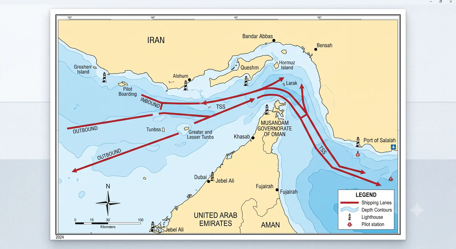
Detailed map of the Strait of Hormuz showing shipping lanes, depth contours, and surrounding countries including Iran, UAE, and Oman.
India’s economic and military geography makes several of these waterways matters of direct national interest. The bulk of India’s oil imports still originates in the Gulf and therefore passes through Hormuz. Container trade with Europe and East Africa relies on the Red Sea–Suez route and therefore on Bab-el-Mandeb. Eastbound trade and energy shipments to and from East Asia transit Malacca. The Indian Navy’s operational reach, the development of the Andaman and Nicobar Command, and participation in multilateral naval exercises are all shaped by the need to monitor and, if necessary, help secure these passages.
India’s growing role as a net security provider in the Indian Ocean Region is partly a response to the vulnerability of these routes. Information-sharing agreements, coastal radar networks, and coordinated patrols with partner countries aim to reduce the risks of piracy, trafficking and interdiction. At the same time, India’s own port development and the International North-South Transport Corridor represent longer-term efforts to diversify connectivity and reduce dependence on any single maritime bottleneck.
Chapter 8
Future Pressures and Alternative Routes
Climate change is already affecting canal operations; low water levels in Panama have forced draft restrictions. Melting Arctic ice is gradually opening the Northern Sea Route, which could eventually offer a shorter Asia–Europe path for some traffic, though political and infrastructural obstacles remain substantial. Proposals for new canals—across the Kra Isthmus in Thailand or alternative Central American routes—surface periodically, yet the engineering, financial and political barriers are high. For the foreseeable future the existing chokepoints will continue to dominate.
Great-power competition adds another layer. Naval modernisation, base access agreements, and the militarisation of artificial islands all take place against the background of these fixed geographical constraints. The power that can protect, interdict or reliably transit these passages holds a persistent advantage.
Chapter 9
Exam Relevance
Questions on straits and canals appear in both the geography and the international relations segments of competitive examinations. Prelims often test precise locations, connecting seas and bordering countries. Mains questions ask for the strategic significance of a particular waterway, the implications of its disruption, or India’s interests in a given passage. Effective answers combine accurate map knowledge with clear analysis of trade volumes, energy flows and naval consequences. Linking a physical feature to current geopolitical tension—Hormuz and energy security, Malacca and East Asian demand, Suez and European–Asian trade—demonstrates the integrated understanding that scores highly.
Closing Perspective
Closing Perspective
The great straits and canals of the world are narrow lines on the map that organise vast movements of goods, energy and power. Their importance does not diminish with technology; if anything, the concentration of modern logistics makes them more critical. For a country such as India, whose growth depends on secure sea lanes and whose navy operates across the Indian Ocean, literacy in this maritime geography is not optional. It is a basic requirement of strategic awareness. The passages described above will continue to shape the possibilities and the vulnerabilities of the international system for decades to come.
Chapter 10
Frequently Asked Questions
Why is the Strait of Hormuz considered the most critical energy chokepoint?
What is the strategic importance of the Strait of Malacca for India and East Asia?
How did the 2021 blockage of the Suez Canal demonstrate its global importance?
Which straits and canals are most directly relevant to India’s energy and trade security?
Ready for the Real Test?
Strengthen your preparation with full-length FREE mock tests, previous year questions, and detailed study notes.
Start Free Mock Tests →Continue on RRBCONTENTS
Explore More
Knowledge Hub
More Blog Articles
In-depth, exam-focused articles on world geography, straits, canals and static GK.
Study Material
Exam Study Notes
Subject-wise notes and digests for Railway, SSC, Banking and UPSC exams.
Current Affairs
Daily Current Affairs & GK
Daily updates and static GK bank with active-recall quizzes.
"The passages described above will continue to shape the possibilities and the vulnerabilities of the international system for decades to come."