Home › Blog › Weather Updates › India Weather July 28 2026

Active Monsoon Deluge: Comprehensive IMD City-by-City Weather Forecast and High-Alert Directory for July 28, 2026
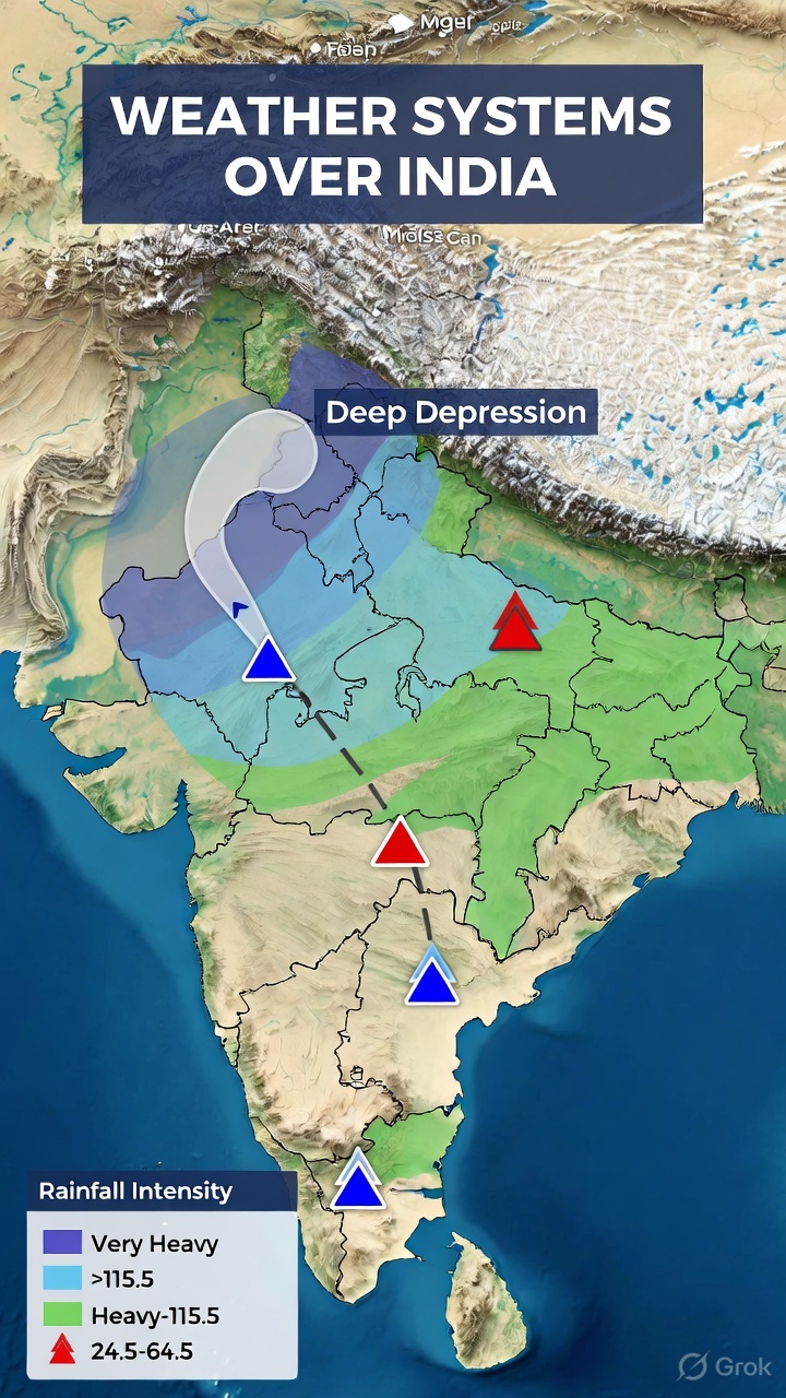
According to official weather bulletins released by the India Meteorological Department (IMD), active monsoon conditions will intensify across major parts of the country on Tuesday, July 28, 2026. The primary meteorological driver is a Deep Depression over the Northwest Bay of Bengal that crossed the West Bengal and North Odisha coasts near Balasore and Canning. As this deep depression moves north-northwestward inland over Gangetic West Bengal, Jharkhand, and adjoining areas, it is pulling immense maritime moisture across central, northern, and eastern India.
Simultaneously, the main Monsoon Trough lies south of its normal position, supported by active upper-air cyclonic circulations over Southwest Rajasthan, Central Uttar Pradesh, and the Arabian Sea. Consequently, the IMD has issued Orange and Red warnings for heavy to extremely heavy rainfall, localized urban flooding, flash floods, and landslides across multiple states.
Below is an exhaustive, city-by-city weather forecast, temperature matrix, hazard risk analysis, and public safety advisory for July 28, 2026.
Table of Contents
- 1. Metropolitan Cities Weather Forecast for July 28, 2026
- 2. Northern India & Himalayan States Forecast
- 3. Eastern & Central India Weather Forecast
- 4. Western & Peninsular India Forecast
- 5. Northeast India Forecast
- 6. Master Weather Data Table for 30 Major Cities (July 28, 2026)
- 7. Safety Advisories & School Holiday Updates
- 8. High-Yield Academic Corner (For Competitive Examinations)
- 9. Key Takeaways / What You Need to Know
Key Takeaways & What You Need to Know
- Primary System: A Deep Depression over the Northwest Bay of Bengal moved inland over West Bengal and North Odisha coasts, triggering heavy rain across North, East, and Central India.
- High-Alert Zones: Delhi-NCR, Gangetic West Bengal, Odisha, Jharkhand, East UP, Himachal Pradesh, Uttarakhand, Punjab, Haryana, Gujarat, and Madhya Maharashtra Ghats.
- Travel Caution: Avoid traveling through landslide-prone mountain highways and waterlogged urban subways.
- Fishermen Warning: Strictly prohibited from entering the North Bay of Bengal and Arabian Sea coastal waters due to squally winds.
1. Metropolitan Cities Weather Forecast for July 28, 2026
1. New Delhi & National Capital Region (Gurugram, Noida, Ghaziabad, Faridabad)
Forecast: Widespread light-to-moderate rain accompanied by heavy to very heavy rainfall spells at isolated places. Thunderstorms with frequent lightning and gusty surface winds ($30\text{--}45\text{ km/h}$) will prevail throughout the day.
Impact: High risk of waterlogging along key arterial roads (ITO, Dhaula Kuan, Delhi-Gurugram Expressway) during morning and evening rush hours. Elevated relative humidity ($80\%\text{--}95\%$).
Temperature: $25^\circ\text{C}$ (Minimum) to $32^\circ\text{C}$ (Maximum).
IMD Alert Status: Orange Alert (Be Prepared)
2. Kolkata & Gangetic West Bengal
Forecast: Heavy to very heavy rainfall at many places, driven by the residual impact of the Deep Depression moving across Canning and Gangetic West Bengal. Squally winds reaching $40\text{--}50\text{ km/h}$ gusting to $60\text{ km/h}$ along coastal areas.
Impact: Severe waterlogging in low-lying urban sectors of Kolkata, Howrah, Hooghly, and South 24 Parganas. Disruption to public transport, ferry services, and low-lying railway tracks.
Temperature: $25^\circ\text{C}$ (Minimum) to $29^\circ\text{C}$ (Maximum).
IMD Alert Status: Orange / Red High Alert
3. Mumbai & Konkan Belt (Thane, Palghar, Raigad, Navi Mumbai)
Forecast: Fairly widespread to widespread light-to-moderate rain, with isolated heavy to very heavy spells over Mumbai, Thane, and Palghar. High sea waves and rough coastal conditions.
Impact: Moderate waterlogging risks in low-lying subway crossings (Andheri, Milan, Hindmata) coinciding with high tide hours. Traffic movement will be sluggish.
Temperature: $25^\circ\text{C}$ (Minimum) to $29^\circ\text{C}$ (Maximum).
IMD Alert Status: Orange Watch
4. Chennai & Northern Tamil Nadu
Forecast: Partly cloudy sky with strong surface winds ($35\text{--}45\text{ km/h}$) and isolated light rain or passing thundershowers.
Impact: Warm and humid weather conditions overall. Coastal sea conditions will remain rough off the Coromandel coast.
Temperature: $27^\circ\text{C}$ (Minimum) to $36^\circ\text{C}$ (Maximum).
IMD Alert Status: Green / Wind Watch
5. Bengaluru & South Interior Karnataka
Forecast: Generally cloudy sky with light-to-moderate passing showers accompanied by breezy surface winds reaching $30\text{--}40\text{ km/h}$.
Impact: Pleasant, cool temperatures throughout the day; minimal urban flooding risk in core city areas.
Temperature: $20^\circ\text{C}$ (Minimum) to $27^\circ\text{C}$ (Maximum).
IMD Alert Status: Yellow Watch
6. Hyderabad & Telangana
Forecast: Generally cloudy sky with light-to-moderate rainfall or thundershowers in scattered areas.
Impact: Intermittent rain spells providing relief from heat; minor localized traffic slowdowns.
Temperature: $23^\circ\text{C}$ (Minimum) to $30^\circ\text{C}$ (Maximum).
IMD Alert Status: Yellow Watch
2. Northern India & Himalayan States Forecast
A. Himachal Pradesh (Shimla, Manali, Kangra, Mandi, Kullu)
Forecast: Widespread rain with heavy to very heavy rainfall at isolated places across mid and lower hill districts.
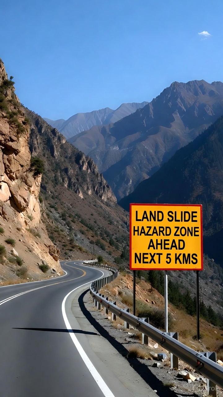
Impact: High risk of landslides, mudslides, and flash floods along mountain highways including the Chandigarh-Manali NH-21. Disruption to local road transit and swollen river streams.
Temperature: Shimla ($17^\circ\text{C} - 22^\circ\text{C}$), Kangra ($21^\circ\text{C} - 26^\circ\text{C}$).
IMD Alert Status: Orange Alert (Take Precautions)
B. Uttarakhand (Dehradun, Mussoorie, Nainital, Haridwar, Rishikesh)
Forecast: Intense monsoon spells with heavy to very heavy rainfall accompanied by active lightning and gusty winds.
Impact: Vulnerability to shooting stones and landslips on Char Dham pilgrimage routes. High water flow in the Ganga, Alaknanda, and Yamuna river catchments.
Temperature: Dehradun ($22^\circ\text{C} - 28^\circ\text{C}$).
IMD Alert Status: Orange Alert
C. Jammu & Kashmir (Jammu, Srinagar, Ramban, Kathua, Udhampur)
Forecast: Fairly widespread light-to-moderate rain with heavy spells over Jammu division (Kathua, Samba, Jammu).
Impact: Landslide watches active along the Jammu-Srinagar National Highway (NH-44), particularly in the Ramban-Banihal sector.
Temperature: Srinagar ($18^\circ\text{C} - 26^\circ\text{C}$), Jammu ($24^\circ\text{C} - 31^\circ\text{C}$).
IMD Alert Status: Yellow / Orange Watch
D. Punjab & Haryana (Chandigarh, Ludhiana, Amritsar, Ambala, Gurugram)
Forecast: Widespread rainfall with heavy to very heavy rain at isolated places across Haryana, Chandigarh, and Punjab.
Impact: Localized waterlogging in agricultural fields and low-lying urban sectors.
Temperature: Chandigarh ($25^\circ\text{C} - 31^\circ\text{C}$).
IMD Alert Status: Orange Alert
E. Uttar Pradesh (Western UP & Eastern UP)
Forecast: Widespread rainfall across Western and Eastern Uttar Pradesh, with heavy to very heavy rainfall expected at isolated places.
Impact: Reduced visibility, localized waterlogging, and riverine monitoring along the Yamuna and Ganga tributaries.
Temperature: Lucknow ($26^\circ\text{C} - 32^\circ\text{C}$), Varanasi ($26^\circ\text{C} - 31^\circ\text{C}$).
IMD Alert Status: Orange Alert
F. Rajasthan (Jaipur, Udaipur, Kota, Jodhpur, Bikaner)
Forecast: Fairly widespread rainfall over East Rajasthan (Jaipur, Kota, Udaipur) with isolated heavy rainfall. West Rajasthan will witness scattered light-to-moderate rain.
Temperature: Jaipur ($26^\circ\text{C} - 33^\circ\text{C}$).
IMD Alert Status: Yellow Alert
3. Eastern & Central India Weather Forecast

A. Odisha (Bhubaneswar, Cuttack, Balasore, Puri, Sambalpur)
Forecast: Widespread rainfall with heavy to very heavy rainfall over coastal and northern districts as the Deep Depression shifts inland.
Impact: Swelling of local rivers; flood warnings active in low-lying basins. Fishermen advised against venturing into the sea.
Temperature: Bhubaneswar ($24^\circ\text{C} - 29^\circ\text{C}$).
IMD Alert Status: Orange Alert
B. Jharkhand & Bihar (Ranchi, Jamshedpur, Dhanbad, Patna, Gaya)
Forecast: Jharkhand: Heavy to very heavy rainfall widespread due to the inland movement of the depression. Bihar: Light to moderate rain with isolated heavy spells over southern and eastern districts.
Impact: High cloud-to-ground lightning hazard in rural agricultural fields.
Temperature: Ranchi ($22^\circ\text{C} - 27^\circ\text{C}$), Patna ($26^\circ\text{C} - 32^\circ\text{C}$).
IMD Alert Status: Jharkhand (Orange Alert), Bihar (Yellow Alert)
C. Madhya Pradesh & Chhattisgarh (Bhopal, Indore, Jabalpur, Raipur)
Forecast: East Madhya Pradesh & Chhattisgarh: Heavy to very heavy rainfall accompanied by persistent thunderstorms and lightning. West Madhya Pradesh: Scattered light-to-moderate rain.
Impact: Inundation of low-level causeways along Narmada and Indravati river basins.
Temperature: Bhopal ($24^\circ\text{C} - 30^\circ\text{C}$), Raipur ($24^\circ\text{C} - 29^\circ\text{C}$).
IMD Alert Status: Orange Alert
4. Western & Peninsular India Forecast

A. Gujarat State (Surat, Navsari, Valsad, Ahmedabad, Rajkot)
Forecast: Fairly widespread heavy rainfall over Gujarat Region (Surat, Navsari, Valsad, Bharuch). Saurashtra & Kutch will receive scattered light-to-moderate rain.
Impact: Inundation of low-lying agricultural fields and urban waterlogging risks.
Temperature: Ahmedabad ($25^\circ\text{C} - 31^\circ\text{C}$).
IMD Alert Status: Orange Watch
B. Maharashtra (Madhya Maharashtra Ghats: Pune, Nashik; Vidarbha: Nagpur)
Forecast: Madhya Maharashtra Ghats: Heavy to very heavy rainfall over isolated mountain passes. Vidarbha & Marathwada: Scattered thundershowers.
Impact: Rapid water inflow into mountain dam reservoirs; flash flood advisories for ghat roads.
Temperature: Pune ($22^\circ\text{C} - 27^\circ\text{C}$), Nagpur ($24^\circ\text{C} - 30^\circ\text{C}$).
IMD Alert Status: Orange Alert (Ghat Areas)
C. Coastal Karnataka & Kerala (Mangaluru, Udupi, Kochi, Thiruvananthapuram)
Forecast: Coastal Karnataka: Fairly widespread heavy rainfall with strong surface winds. Kerala & Mahe: Moderate rain with isolated heavy spells and gusty winds ($40\text{--}50\text{ km/h}$).
Impact: Rough sea conditions; high wave warnings along the Arabian Sea coast.
Temperature: Mangaluru ($24^\circ\text{C} - 28^\circ\text{C}$), Kochi ($24^\circ\text{C} - 29^\circ\text{C}$).
IMD Alert Status: Yellow / Orange Alert
5. Northeast India Forecast
Coverage: Assam, Meghalaya, Arunachal Pradesh, Nagaland, Manipur, Mizoram, Tripura
Forecast: Widespread light-to-moderate rain with isolated heavy rainfall across Assam, Meghalaya, Arunachal Pradesh, Nagaland, Manipur, Mizoram, and Tripura.
Impact: Sustained water levels in the Brahmaputra river basin; localized mudslides in hilly terrain.
Temperature: Guwahati ($26^\circ\text{C} - 32^\circ\text{C}$), Shillong ($18^\circ\text{C} - 24^\circ\text{C}$).
IMD Alert Status: Yellow Alert
6. Master Weather Data Table for 30 Major Cities (July 28, 2026)
| City | Expected Weather Condition | Temp Range (°C) | IMD Alert Status | Primary Risk |
|---|---|---|---|---|
| New Delhi | Heavy to Very Heavy Rain, Thunderstorms | $25^\circ\text{C} - 32^\circ\text{C}$ | Orange Alert | Urban Waterlogging & Traffic |
| Kolkata | Heavy to Very Heavy Rain, Squally Winds | $25^\circ\text{C} - 29^\circ\text{C}$ | Orange / Red | Severe Inundation & Transport |
| Mumbai | Moderate to Heavy Showers | $25^\circ\text{C} - 29^\circ\text{C}$ | Orange Watch | Subway Flooding / High Tide |
| Chennai | Strong Surface Winds, Light Rain | $27^\circ\text{C} - 36^\circ\text{C}$ | Green / Wind | Choppy Sea Conditions |
| Bengaluru | Passing Light Showers, Breezy | $20^\circ\text{C} - 27^\circ\text{C}$ | Yellow Watch | Mild Traffic Slowdowns |
| Hyderabad | Light to Moderate Thundershowers | $23^\circ\text{C} - 30^\circ\text{C}$ | Yellow Watch | Minor Localized Rain |
| Bhubaneswar | Heavy Rain, Thunderstorms | $24^\circ\text{C} - 29^\circ\text{C}$ | Orange Alert | River Swelling & Lightning |
| Ahmedabad | Heavy Rain Spells | $25^\circ\text{C} - 31^\circ\text{C}$ | Orange Watch | Low-lying Waterlogging |
| Surat | Heavy to Very Heavy Rain | $25^\circ\text{C} - 30^\circ\text{C}$ | Orange Alert | Field Inundation |
| Shimla | Heavy Mountain Rain, Landslides | $17^\circ\text{C} - 22^\circ\text{C}$ | Orange Alert | Landslides & Road Blocks |
| Dehradun | Very Heavy Rain, Flash Floods | $22^\circ\text{C} - 28^\circ\text{C}$ | Orange Alert | River Catchment Surges |
| Lucknow | Widespread Heavy Rain | $26^\circ\text{C} - 32^\circ\text{C}$ | Orange Alert | Localized Inundation |
| Patna | Moderate to Heavy Showers | $26^\circ\text{C} - 32^\circ\text{C}$ | Yellow Alert | Lightning Hazard |
| Ranchi | Heavy to Very Heavy Rain | $22^\circ\text{C} - 27^\circ\text{C}$ | Orange Alert | Waterlogging & Winds |
| Bhopal | Moderate to Heavy Rain | $24^\circ\text{C} - 30^\circ\text{C}$ | Yellow / Orange | Causeways Overflow |
| Raipur | Heavy Rain Spells | $24^\circ\text{C} - 29^\circ\text{C}$ | Orange Alert | Lowland Inundation |
| Jaipur | Scattered Heavy Rain | $26^\circ\text{C} - 33^\circ\text{C}$ | Yellow Alert | Local Traffic Disturbance |
| Chandigarh | Heavy to Very Heavy Rain | $25^\circ\text{C} - 31^\circ\text{C}$ | Orange Alert | Urban Waterlogging |
| Srinagar | Light to Moderate Rain | $18^\circ\text{C} - 26^\circ\text{C}$ | Yellow Watch | Minor Landslips in Hills |
| Jammu | Heavy Rain Spells | $24^\circ\text{C} - 31^\circ\text{C}$ | Orange Watch | Highway Disruptions (NH-44) |
| Guwahati | Heavy Rain Spells | $26^\circ\text{C} - 32^\circ\text{C}$ | Yellow Alert | River Spate Watch |
| Shillong | Heavy Mountain Showers | $18^\circ\text{C} - 24^\circ\text{C}$ | Yellow Alert | Localized Slips |
| Mangaluru | Heavy Coastal Rain | $24^\circ\text{C} - 28^\circ\text{C}$ | Orange Alert | High Waves & Rough Sea |
| Kochi | Moderate to Heavy Showers | $24^\circ\text{C} - 29^\circ\text{C}$ | Yellow Watch | Gusty Winds ($50\text{ km/h}$) |
| Pune | Heavy Rain in Ghat Areas | $22^\circ\text{C} - 27^\circ\text{C}$ | Orange (Ghats) | Dam Catchment Inflows |
| Nashik | Heavy Rain in Ghat Belts | $22^\circ\text{C} - 28^\circ\text{C}$ | Orange (Ghats) | River Catchment Inflows |
| Nagpur | Light to Moderate Rain | $24^\circ\text{C} - 30^\circ\text{C}$ | Yellow Watch | Minor Thundershowers |
| Visakhapatnam | Scattered Rain, Gusty Winds | $26^\circ\text{C} - 33^\circ\text{C}$ | Yellow Watch | Rough Coastal Waters |
| Vijayawada | Light to Moderate Showers | $26^\circ\text{C} - 34^\circ\text{C}$ | Yellow Watch | Humid Weather |
| Agartala | Heavy Rain Spells | $25^\circ\text{C} - 31^\circ\text{C}$ | Yellow Alert | Lowland Waterlogging |
7. Safety Advisories & School Holiday Updates for July 28, 2026
Due to heavy rainfall alerts issued across coastal, central, and northern districts, local administrations in several states have evaluated safety protocols:
- School Closure Status: District Collectors in coastal Odisha (Balasore, Bhadrak, Puri), South Bengal (South 24 Parganas, Kolkata), parts of South Gujarat (Surat, Navsari, Valsad), and specific hill districts of Himachal Pradesh and Uttarakhand have advised local educational institutions to remain prepared for potential physical school closures or online classes based on overnight rainfall intensity.
- Disaster Response Teams: National Disaster Response Force (NDRF) and State Disaster Response Force (SDRF) teams have been pre-positioned in vulnerable flood plains across Odisha, West Bengal, Gujarat, Maharashtra, and Himachal Pradesh.
- Travel Safety Rules:
- Avoid crossing flooded roads, causeways, or underpasses.
- Avoid non-essential travel along hilly highways in Himachal Pradesh, Uttarakhand, and Jammu & Kashmir due to active landslide risks.
- Stay away from electric poles, fallen wires, and loose metallic structures during electrical storms.
8. High-Yield Academic Corner (For Competitive Examinations)
For candidates preparing for UPSC Civil Services (GS Paper 1: Physical Geography & GS Paper 3: Disaster Management):
A. Deep Depression Dynamics
Definition: A tropical low-pressure system where wind speeds range between 28 to 33 knots ($52\text{ to }61\text{ km/h}$). When a depression intensifies into a Deep Depression over oceanic waters like the Bay of Bengal, it transports high latent heat and moisture inland, driving heavy precipitation.
B. Monsoon Trough Position
- Active Phase: When the Monsoon Trough lies south of its normal position, it causes intense rain activity across Central, Western, and Northern India.
- Break Phase: When the trough shifts north toward the Himalayan foothills, leading to heavy rain in the mountains and dry conditions across the Indian plains.
Stay Updated with Daily Weather & Current Affairs on RRBCONTENTS
Get verified weather updates, exam alerts, and daily current affairs digests delivered to your mobile.
Daily Current Affairs → Geography Study Notes →Join our official Telegram channel: @rrbcontents