Home › Blog › Weather & Environment › India Weather Forecast Tomorrow
India Weather Forecast Tomorrow: Comprehensive City-Wise Outlook & IMD Alerts
Track recruitment notices for IMD Scientific Assistant, Disaster Management Officers & Govt exam updates on RRBCONTENTS Jobs Portal.
Key Takeaways & Forecast Summary
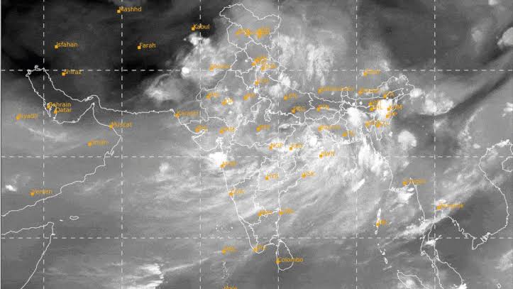
- Vigorous Monsoon Surge: A well-marked low-pressure area over the Bay of Bengal and an off-shore trough along the West Coast are driving heavy rainfall across India.
- Mumbai & Konkan Orange/Red Alert: Mumbai, Thane, and Palghar face heavy to very heavy downpours with high-tide urban waterlogging risks and squally winds up to 55 km/h.
- Himalayan Landslide Risk: Himachal Pradesh (Shimla, Manali) and Uttarakhand (Dehradun, Nainital) remain under Orange Alerts for cloudbursts and landslides.
- Delhi-NCR Yellow Alert: High humidity (75–90%) with scattered light to moderate afternoon rain spells in New Delhi, Noida, and Gurugram.
Table of Contents
- 1. Key Synoptic Weather Systems Driving Tomorrow's Weather
- 2. City-by-City Detailed Weather Forecast for Tomorrow
- 3. National City Weather Summary Table
- 4. Impact Analysis: Daily Life, Transport, Agriculture & Infrastructure
- 5. Exam Corner: Climatology & Meteorology for Competitive Exams
- 6. Practical Safety Guidelines for Citizens Tomorrow
1. Key Synoptic Weather Systems Driving Tomorrow's Weather
As the Southwest Monsoon reaches its peak intensity across the Indian subcontinent, citizens across metropolitan hubs, agricultural belts, and hilly terrains are keeping a close eye on the skies. The India Meteorological Department (IMD) has issued a fresh bulletin detailing the synoptic weather systems that will govern atmospheric conditions across northern, western, central, eastern, northeastern, and southern regions of the country tomorrow, Friday, July 24, 2026.
Active monsoonal surges, driven by a well-marked low-pressure area over the Bay of Bengal, a persistent off-shore trough along the Arabian Sea coast, and a weak western disturbance over the upper Himalayas, are set to bring varied weather patterns across India. While coastal cities like Mumbai and hill states like Himachal Pradesh and Uttarakhand brace for heavy to very heavy downpours, northern plains including Delhi-NCR will experience warm, humid conditions with scattered monsoon showers.
Whether you are a daily commuter navigating urban transit, an agricultural worker monitoring Kharif crop irrigation, a traveler planning hill journeys, or an aspirant preparing for competitive examinations (UPSC, SSC, RRB, and State PSCs), this comprehensive weather news report provides a complete, research-backed breakdown of what to expect tomorrow across major Indian cities.
| Synoptic System | Location & Operational Impact |
|---|---|
| 1. Low-Pressure Area | Active over Northwest Bay of Bengal & Odisha coast; pulling moisture across Eastern and Central India. |
| 2. Monsoon Trough | Positioned south of normal position, channelling winds from both Arabian Sea and Bay of Bengal. |
| 3. Off-Shore Trough | Stretching continuously along Konkan-Goa & Karnataka coast; triggering coastal deluges. |
| 4. Western Disturbance | Upper-tropospheric trough interacting with monsoonal winds over the Western Himalayan Region. |
The Bay of Bengal Low-Pressure System: A well-marked low-pressure system situated off the northern Odisha and West Bengal coasts continues to channel dense moisture-laden easterly winds across Eastern and Central India. This system is driving heavy rainfall across Odisha, Chhattisgarh, Gangetic West Bengal, and eastern Madhya Pradesh.
The Arabian Sea Off-Shore Trough: Running continuously from the south Gujarat coast down to the Karnataka-Kerala coast, this low-level pressure trough is pumping heavy moisture into the Western Ghats. It remains the primary cause for the sustained, heavy downpours along the Konkan belt, including Mumbai, Thane, Raigad, and Goa.
Monsoon Trough Alignment: The main axis of the monsoon trough is currently lying slightly south of its normal position, passing through Rajasthan, Madhya Pradesh, Chhattisgarh, and extending into the low-pressure center over the Bay of Bengal. This alignment ensures widespread rainfall activity across central and western plains.
Himalayan Orographic Interaction: In the north, moisture-laden southwesterly winds are striking the steep mountain slopes of Himachal Pradesh and Uttarakhand. Combined with a weak upper-air trough, this interaction increases the risk of localized cloudbursts, flash floods, and landslides in hill districts.
2. City-by-City Detailed Weather Forecast for Tomorrow
Below is an extensive regional and city-wise breakdown of expected weather parameters, including temperature ranges, rainfall probability, sky conditions, and official IMD alert levels for tomorrow.
Zone 1: North India & National Capital Region (NCR)
- New Delhi & NCR (Noida, Gurugram, Ghaziabad): Min 27°C, Max 34°C. Generally cloudy sky with light to moderate rain or thundershowers. High humidity (75–90%). Patchy morning drizzles giving way to moderate evening spells. IMD Alert: Yellow Alert.
- Chandigarh, Punjab & Haryana: Min 26°C, Max 33°C. Partly cloudy to generally overcast skies with scattered light to moderate rainfall. Favorable for paddy transplanting. IMD Alert: Green to Yellow Alert.
- Jaipur & Rajasthan: Min 25°C, Max 35°C (West); Min 24°C, Max 32°C (East). Good rainfall in Eastern districts (Kota, Udaipur); isolated showers in Western desert belts. IMD Alert: Yellow Alert (East); Green Alert (West).
- Lucknow & Uttar Pradesh: Min 26°C, Max 33°C. Overcast skies with light to moderate rain and thunderstorm activity driven by easterly winds. IMD Alert: Yellow Alert.
Zone 2: Western Himalayan Region (High Risk Alert Zones)
- Shimla & Himachal Pradesh (Manali, Dharamshala): Min 16°C, Max 22°C. Continuous heavy downpours. High risk of landslides, rockfalls along NH-21 and NH-5, and sudden river surges in Beas and Sutlej. IMD Alert: Orange Alert.
- Dehradun & Uttarakhand (Mussoorie, Nainital): Min 22°C, Max 28°C. Overcast with intense rain spells. Char Dham route travelers advised to check road clearance bulletins. IMD Alert: Orange Alert.
- Srinagar & Jammu & Kashmir: Min 18°C, Max 29°C (Srinagar); Min 24°C, Max 32°C (Jammu). Moderate rain in Jammu region; light showers in Kashmir valley. IMD Alert: Green to Yellow Alert.
Zone 3: Western & Central India (Coastal & Ghat Deluges)
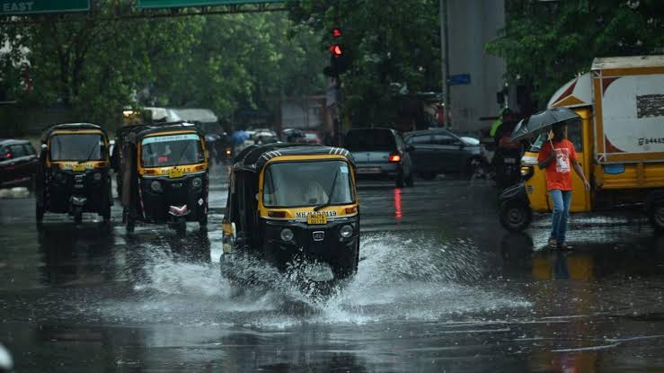
- Mumbai & Konkan Region (Thane, Raigad, Palghar): Min 24°C, Max 29°C. Overcast with continuous heavy rain and isolated extremely heavy downpours. High tide waterlogging risks in low-lying areas (Hindmata, Kurla, Sion, Andheri subway). Coastal winds gusting up to 55 km/h. IMD Alert: Orange to Red Alert.
- Pune & Interior Maharashtra: Min 21°C, Max 27°C. Light to moderate rain in Pune city; very heavy rain in adjoining ghats (Lonavala, Khandala, Tamhini). IMD Alert: Orange Alert (Ghats); Yellow Alert (Plains).
- Ahmedabad & Gujarat (Surat, Vadodara): Min 25°C, Max 32°C. Heavy rainfall spells across South Gujarat and coastal Saurashtra; light to moderate showers in Central Gujarat. IMD Alert: Orange Alert (South Gujarat).
- Bhopal & Madhya Pradesh: Min 23°C, Max 29°C. Overcast with widespread moderate rain, heavy spells in eastern MP (Jabalpur, Rewa). IMD Alert: Yellow to Orange Alert.
Zone 4: East & Northeast India
- Kolkata & West Bengal: Min 26°C, Max 31°C (Kolkata); Min 22°C, Max 27°C (Siliguri). Humid with passing showers in Kolkata; heavy to very heavy rain in North Bengal hills. IMD Alert: Yellow Alert (South); Orange Alert (North).
- Bhubaneswar & Odisha: Min 24°C, Max 30°C. Vigorous monsoon activity near the Bay of Bengal low-pressure system. Heavy rain in Cuttack, Puri, Sambalpur. IMD Alert: Orange Alert.
- Patna & Bihar: Min 26°C, Max 33°C. Warm, muggy conditions with scattered light to moderate showers. IMD Alert: Yellow Alert.
- Guwahati & North-East India (Shillong): Min 25°C, Max 31°C. Widespread heavy rainfall across Brahmaputra valley and Meghalaya plateau. IMD Alert: Orange Alert.
Zone 5: South Peninsular India
- Bengaluru & Karnataka: Min 20°C, Max 27°C (Bengaluru); Min 23°C, Max 28°C (Mangaluru). Pleasant, breezy weather in Bengaluru; heavy downpours along Coastal Karnataka. IMD Alert: Green/Yellow Alert (Bengaluru); Orange Alert (Coastal).
- Chennai & Tamil Nadu: Min 26°C, Max 36°C. Warm and humid in rain-shadow zone; minor evening sea-breeze drizzles possible. IMD Alert: Green Alert.
- Hyderabad & Telangana: Min 22°C, Max 30°C. Comfortable daytime temperatures with scattered light-moderate rain. IMD Alert: Yellow Alert.
- Kochi & Kerala: Min 24°C, Max 29°C. Overcast with active rain spells in northern coastal districts. IMD Alert: Yellow Alert.
3. National City Weather Summary Table for Tomorrow
For a quick reference across major urban capitals, the table below consolidates expected temperature ranges, sky conditions, rainfall forecasts, and official IMD alert statuses for tomorrow:
| Major City | Min Temp (°C) | Max Temp (°C) | Expected Sky / Weather Condition | IMD Warning Level |
|---|---|---|---|---|
| New Delhi | 27°C | 34°C | Generally cloudy, light to moderate rain spells | Yellow Alert |
| Mumbai | 24°C | 29°C | Heavy to very heavy rain, coastal squalls | Orange Alert |
| Kolkata | 26°C | 31°C | Cloudy, humid, passing moderate showers | Yellow Alert |
| Chennai | 26°C | 36°C | Partly cloudy, warm, isolated light drizzles | Green Alert |
| Bengaluru | 20°C | 27°C | Pleasant, breezy, intermittent light-moderate rain | Green Alert |
| Hyderabad | 22°C | 30°C | Overcast, light to moderate scattered showers | Yellow Alert |
| Ahmedabad | 25°C | 32°C | Cloudy, moderate rain, high humidity | Yellow Alert |
| Shimla | 16°C | 22°C | Heavy rain, risk of localized landslides | Orange Alert |
| Dehradun | 22°C | 28°C | Heavy to very heavy rain, hill stream surges | Orange Alert |
| Guwahati | 25°C | 31°C | Widespread heavy rainfall, overcast | Orange Alert |
| Patna | 26°C | 33°C | Muggy, light to moderate scattered rain | Yellow Alert |
| Bhubaneswar | 24°C | 30°C | Widespread heavy rain, coastal winds | Orange Alert |
| Jaipur | 25°C | 35°C | Variable clouds, light to moderate rain | Yellow Alert |
| Lucknow | 26°C | 33°C | Overcast, steady light to moderate showers | Yellow Alert |
| Srinagar | 18°C | 29°C | Partly cloudy, pleasant, brief light rain | Green Alert |
4. Impact Analysis: Daily Life, Transport, Agriculture & Infrastructure
Tomorrow’s monsoonal activity across India carries direct real-world implications for municipal transit, aviation, agricultural operations, and water reservoir management:
| Sector | Expected Weather Impact & Operations |
|---|---|
| Urban Mobility & Transport | Potential waterlogging in Mumbai, Surat, Guwahati, and low-lying Delhi underpasses. Rail and road transit slow-downs. |
| Aviation & Maritime | Crosswinds & low visibility flight delays at Mumbai, Dehradun, Bagdogra. Fisherman advisories active along Konkan & Odisha. |
| Agriculture (Kharif Sowing) | Favorable soil moisture for Paddy, Soy, Pulses in Punjab, UP, MP, MH. Adequate field drainage required in lowlands. |
| River & Dam Management | Active inflow monitoring at Bhakra, Hirakud, Sardar Sarovar, and Tehri dams. |
A. Urban Transit and Commuter Advisory
In metropolitan centers under Orange Alerts—most notably Mumbai, Thane, Surat, and Dehradun—commuters should anticipate potential delays on suburban rail networks and major arterial roads. Waterlogging in customary low-lying underpasses could slow down evening traffic. Public transport authorities in Mumbai have deployed emergency de-watering pumps at sensitive locations.
B. Aviation and Coastal Maritime Operations
Airports in high-rainfall zones—such as Mumbai (BOM), Dehradun (DED), Bagdogra (IXB), and Mangaluru (IXE)—may experience brief flight holding times or diversion risks due to cloud-base drops, heavy rain sheets, and low visibility during peak storm passes. Fishermen along the coasts of Gujarat, Maharashtra, Goa, Odisha, and West Bengal are strictly advised against venturing into deep waters due to rough sea waves and squally winds reaching 40 to 50 km/h.
C. Agriculture & Kharif Crop Impact
For India's agricultural sector, the active monsoon spell tomorrow brings largely positive news for Kharif season crops:
- Paddy (Rice): Abundant soil moisture across Punjab, Haryana, Uttar Pradesh, Bihar, West Bengal, and Odisha supports healthy transplanting and early vegetative growth.
- Pulses & Oilseeds: Rain spells across Madhya Pradesh, Maharashtra, and Gujarat provide essential moisture for soybean, groundnut, and pigeon pea (tur) crops. However, farmers in low-lying fields must ensure adequate field drainage to prevent root rot from prolonged water standing.
5. Exam Corner: Climatology & Meteorology for Competitive Exams
For candidates preparing for UPSC CSE (GS Paper 1: Physical Geography), State PSCs, SSC CGL, and Railway Recruitment Board (RRB) examinations, tracking daily weather forecasts provides practical context for static climatology concepts. Here are key syllabus-aligned terms and systems to remember:
UPSC & Competitive Exam Climatology Concepts
- Southwest Monsoon (Advancing Monsoon): Occurs from June to September, driven by differential heating of land and sea, northwards shift of the Inter-Tropical Convergence Zone (ITCZ), and southwesterly cross-equatorial trade winds.
- Monsoon Trough: An elongated low-pressure zone extending from West Rajasthan to the Head Bay of Bengal. Its shifting position governs rainfall distribution across India.
- Off-Shore Trough: A narrow coastal trough formed by pressure differences between the Arabian Sea and Western Ghats landmass, generating heavy orographic rain along Konkan, Goa, and Kanara coasts.
- Orographic Lift: Precipitation produced when moisture-laden air is forced upward over topographic barriers (Western Ghats or Himalayas), cooling adiabatically into rain clouds.
B. IMD Warning Color Codes
| Color Code | Meaning / Severity | Recommended Action |
|---|---|---|
| Green | No Warning (Normal weather) | No action required; stay informed. |
| Yellow | Watch and Stay Updated | Weather likely to deteriorate; keep track of local forecasts. |
| Orange | Be Prepared | Severe weather expected; prepare for potential disruptions. |
| Red | Take Action | Extremely severe weather imminent; follow safety/evacuation orders. |
6. Practical Safety Guidelines for Citizens Tomorrow
- Check Real-Time Transit Updates: If commuting in Mumbai, Thane, Dehradun, or North Bengal, check official municipal transport app alerts or traffic police social channels before stepping out.
- Avoid Waterlogged Roads & Open Drains: Do not attempt to drive through flooded underpasses or walk near uncovered storm drains where water depth can be deceptive.
- Mountain Travel Precautions: Avoid non-essential road travel along landslide-prone hill corridors in Himachal Pradesh (NH-21) and Uttarakhand during heavy rain hours.
- Lightning Safety: During active thundershowers, stay indoors away from metal structures, tall trees, and open fields. Unplug sensitive electrical appliances.
- Health & Sanitation: Drink boiled or filtered water during monsoon months to protect against waterborne diseases such as gastroenteritis, typhoid, and cholera.
Interactive Geography & Climatology Quiz
Q1. Which meteorological feature causes heavy rainfall along the Konkan coast of Maharashtra?
A) Western Disturbance
B) Arabian Sea Off-Shore Trough
C) Northeast Monsoon
D) Tropical Cyclone
Correct Answer: B
Explanation: The Arabian Sea Off-Shore Trough channels heavy moisture into the Western Ghats, driving sustained rains along the Konkan belt.
Q2. What does an "Orange Alert" issued by IMD signify?
A) Normal weather
B) Watch and stay updated
C) Be prepared for severe weather disruptions
D) Immediate evacuation
Correct Answer: C
Explanation: Orange Alert advises citizens and authorities to "Be Prepared" for potential power and traffic disruptions due to severe weather.
Prepare for Geography & Environmental Current Affairs
Explore free climatology study notes, IMD weather breakdowns, and competitive exam preparation materials on RRBCONTENTS.
Solve Geography PYQs → Check Disaster Management Jobs →Join our official Telegram community: @rrbcontents