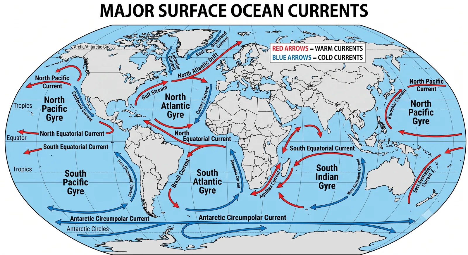
Map displaying major surface ocean currents of the world including warm and cold currents like Gulf Stream and Humboldt Current

Across their surface and in their depths, vast rivers of water move continuously, carrying heat, nutrients, salt and momentum from one part of the planet to another.

Chapter 1

The Driving Mechanisms

Solar

Heating Gradient

Drives thermal expansion at equator and sinking at poles

Coriolis

Earth Deflection

Rightward in North, Leftward in South creating gyres

Winds

Surface Friction

Trade winds & Westerlies drive major horizontal currents

Density

Thermohaline

Temperature & salinity drive deep ocean overturning

The oceans are never still. Across their surface and in their depths, vast rivers of water move continuously, carrying heat, nutrients, salt and momentum from one part of the planet to another. These ocean currents form one of the primary mechanisms by which the Earth redistributes energy and sustains marine life. For students of geography they are as fundamental as the planetary wind belts or the monsoon system. A clear grasp of their origin, pattern and consequences is indispensable for understanding climate distribution, desert locations, fishing grounds and even long-term climate variability.

This article examines ocean currents systematically. It begins with the forces that generate them and the principal types, moves across the major currents of each ocean basin, and then analyses their concrete effects on temperature, rainfall, fog, desert formation and fisheries. Indian Ocean currents receive particular attention because of their direct relevance to the subcontinent’s climate and marine resources.

Ocean currents arise from the interplay of several forces. Unequal solar heating between low and high latitudes creates density differences. Warm water near the equator is less dense and tends to move poleward; cold polar water is denser and sinks or moves equatorward. The Earth’s rotation deflects moving water through the Coriolis force—rightward in the Northern Hemisphere and leftward in the Southern Hemisphere—producing the characteristic gyre patterns. Prevailing winds exert drag on the sea surface, transferring momentum and generating the major wind-driven currents. Differences in salinity, caused by evaporation, precipitation, river inflow and ice formation, further modify density and help drive the deep thermohaline circulation. Finally, the configuration of coastlines and mid-ocean ridges steers currents into stable paths.

These forces operate together. Surface currents are dominated by wind and Coriolis effects; deep currents are driven primarily by density differences. The entire system is linked in a global overturning circulation sometimes called the Great Ocean Conveyor Belt.
Chapter 2

Classification of Ocean Currents

Currents are commonly classified in three overlapping ways.

  • By temperature: warm currents carry water warmer than the surrounding sea and generally move poleward from low latitudes; cold currents carry cooler water and usually move equatorward from higher latitudes or rise from depth.
  • By depth: surface currents occupy roughly the upper 400 metres and are largely wind-driven; deep currents move through the ocean interior and form part of the thermohaline circulation.
  • By driving force: wind-driven (or horizontal) currents versus density-driven (thermohaline) currents. Many major currents are mixed in origin.
Western Boundary Currents

Fast, Narrow & Deep Warm Streams

Located on the western sides of ocean basins. They transport solar heat rapidly from the tropics toward higher latitudes.

Gulf Stream Kuroshio Brazil Current Agulhas
Eastern Boundary Currents

Slower, Broader & Upwelling-Rich Streams

Located on the eastern sides of ocean basins. They bring cooler water equatorward and are frequently associated with rich coastal upwelling.

Canary California Humboldt / Peru Benguela

A further practical distinction is between western boundary currents and eastern boundary currents. Western boundary currents (Gulf Stream, Kuroshio, Brazil Current, Agulhas) are fast, narrow and deep; eastern boundary currents (Canary, California, Humboldt/Peru, Benguela) are slower, broader and shallower, and are frequently associated with upwelling.

Chapter 3

Major Currents of the World Oceans

Ocean Basin

Atlantic Ocean

The North Atlantic Gyre is dominated by the Gulf Stream and its extension, the North Atlantic Drift. The Gulf Stream originates in the Gulf of Mexico, exits through the Straits of Florida, and flows northeastward along the North American coast before turning east. It transports enormous quantities of heat toward Europe. The Canary Current completes the eastern side of the gyre, bringing cooler water southward along the North African coast. In the South Atlantic the Brazil Current carries warm water southward, while the Benguela Current brings cold, nutrient-rich water northward along the southwest African coast.

Ocean Basin

Pacific Ocean

The North Pacific Gyre features the Kuroshio (Japan Current), a strong western boundary current analogous to the Gulf Stream, and the California Current on the eastern side. The South Pacific is dominated by the East Australian Current and the powerful Peru or Humboldt Current. The Humboldt Current is one of the most productive marine systems on Earth because persistent upwelling brings nutrients to the surface.

Ocean Basin

Indian Ocean

The Indian Ocean circulation is unique because it is strongly influenced by the seasonal monsoon winds. During the southwest monsoon a strong Somali Current flows northward along the East African coast and intense upwelling occurs off Somalia and Oman. The Southwest Monsoon Current moves eastward across the Arabian Sea and Bay of Bengal. In the northeast monsoon season the pattern largely reverses. The Agulhas Current, flowing southward along the southeast African coast, is the strongest western boundary current in the Southern Hemisphere and plays a key role in the exchange of water between the Indian and Atlantic Oceans.

Circumpolar Link

Southern Ocean

The Antarctic Circumpolar Current is the only current that circles the globe without interruption by continents. Driven by the prevailing westerlies, it connects the Atlantic, Pacific and Indian Oceans and forms a critical link in the global thermohaline circulation.

Practice This Topic

Strengthen your preparation with previous year questions, mock tests, and detailed study notes.

Solve PYQs → Study Notes → Join Telegram →

Chapter 4

Effects on Climate

Ocean currents exert a decisive influence on regional climates by transporting heat and moisture.

Warm currents raise the temperature of adjacent coastal lands and increase evaporation, often producing milder, wetter conditions. The North Atlantic Drift keeps the ports of western Europe ice-free in winter and contributes to the mild climate of the British Isles and Norway at latitudes that are bitterly cold on the opposite side of the Atlantic. The Kuroshio moderates the climate of Japan and supports higher humidity along its path.

Cold currents cool the air above them, reduce evaporation and frequently create stable atmospheric conditions that suppress rainfall. The presence of cold water just offshore is a major reason for the location of coastal deserts: the Atacama (Humboldt Current), the Namib (Benguela Current), and the desert stretches of Baja California (California Current). Cold currents also promote fog formation when moist air moves over the chilled water surface; the frequent fogs of the Grand Banks and the California coast are classic examples.

Currents interact with the atmosphere to influence larger climate patterns. The El Niño–Southern Oscillation is intimately linked to changes in the strength and temperature of equatorial Pacific currents and upwelling. When the normal cold upwelling off Peru weakens, global rainfall and temperature patterns shift, affecting monsoon strength, droughts and floods across several continents. Indian Ocean Dipole events similarly involve changes in equatorial current and temperature patterns that modify rainfall over East Africa and Indonesia and can influence the Indian monsoon.

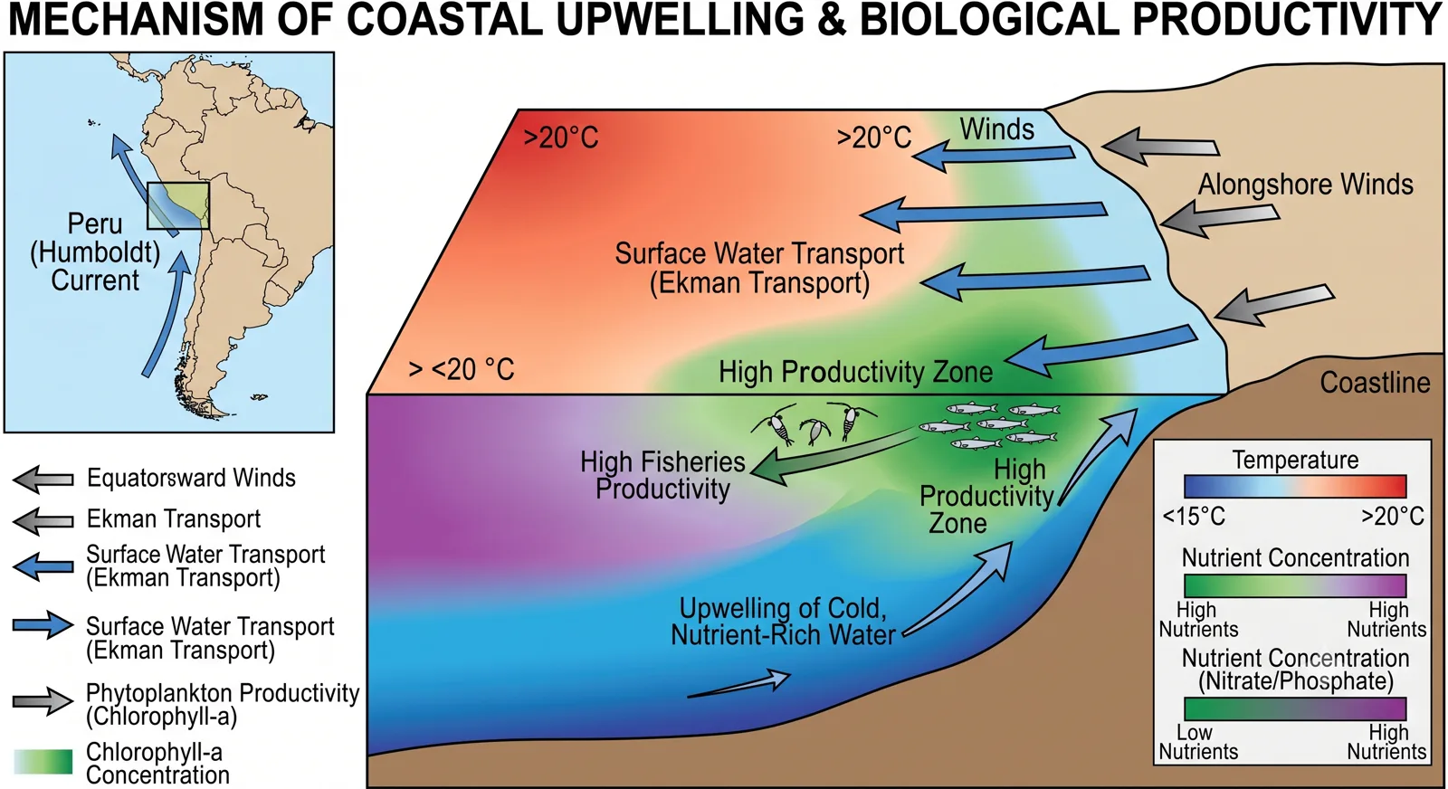
Diagram illustrating the mechanism of coastal upwelling and biological productivity highlighting the Humboldt Current and Ekman transport

Chapter 5

Effects on Fisheries

The biological productivity of the oceans is uneven. The richest fishing grounds are closely associated with areas of upwelling, where cold, nutrient-rich water rises to the sunlit surface and supports dense phytoplankton growth. That phytoplankton forms the base of short, efficient food chains leading to large stocks of fish.

The major upwelling zones lie beneath the eastern boundary currents: the Humboldt system off Peru and Chile, the Benguela system off Namibia and South Africa, the Canary system off Northwest Africa, and the California system. The Humboldt Current region alone has historically supported some of the world’s largest industrial fisheries, particularly for anchovy. The Somali upwelling during the southwest monsoon creates a seasonal burst of productivity in the western Arabian Sea that benefits tuna and other species.

Warm currents can also support fisheries, but usually through different mechanisms—transport of larvae, creation of frontal zones where different water masses meet, or maintenance of suitable temperatures for particular species. The meeting of the warm Gulf Stream and the cold Labrador Current off Newfoundland creates one of the classic frontal fishing grounds.

Human exploitation has repeatedly demonstrated both the wealth and the fragility of these systems. Overfishing, combined with climate-driven shifts in current strength and upwelling intensity, has led to dramatic collapses and recoveries in several of the world’s great fisheries. Understanding the underlying current dynamics is therefore essential for sustainable management.

Chapter 6

Indian Ocean Currents and the Subcontinent

For India the relevant currents are primarily those of the northern Indian Ocean. The seasonally reversing monsoon currents influence sea-surface temperatures in the Arabian Sea and Bay of Bengal, which in turn affect the strength and distribution of monsoon rainfall. Upwelling along the southwest coast of India during the summer monsoon brings nutrients that support local fisheries, especially for oil sardine and mackerel. The Somali Current and associated upwelling further west influence the broader regional ecosystem and the tuna fisheries of the western Indian Ocean.

Cyclogenesis in the Bay of Bengal and Arabian Sea is also modulated by sea-surface temperature patterns that are partly shaped by current-driven heat distribution. Accurate forecasting therefore requires attention to oceanographic as well as atmospheric conditions.

Chapter 7

Long-term Change and Contemporary Relevance

There is growing evidence that the major current systems are responding to anthropogenic climate change. The Atlantic Meridional Overturning Circulation, of which the Gulf Stream is a surface expression, has shown signs of slowing in some observational records. Changes in the strength of upwelling currents can alter the productivity of entire ecosystems. Shifts in the timing or intensity of monsoon currents affect both rainfall and marine livelihoods around the Indian Ocean rim. These possibilities make ocean currents a live topic in climate science and in discussions of future food and economic security.

Chapter 8

Exam Relevance & Closing Perspective

Exam Relevance

Ocean currents are a high-frequency topic in the physical geography portion of competitive examinations. Questions test knowledge of specific currents and their temperature character, the climatic consequences for adjacent coasts, the location of major fishing grounds, and the mechanisms of upwelling. Map-based questions frequently require candidates to identify currents or to explain the desert–current relationship. Mains answers that link a current to both climatic and biological outcomes, or that explain the seasonal uniqueness of the Indian Ocean circulation, demonstrate the conceptual command examiners look for.

Closing Perspective

Ocean currents are the circulating bloodstream of the planet’s climate and marine ecosystems. They move heat from the tropics toward the poles, create the conditions for the world’s most productive fisheries, and help determine which coasts are moist and temperate and which are arid. Their patterns are regular enough to be mapped and predicted, yet sensitive enough to climate change to remain a subject of active scientific concern. For the geography student they offer a clear illustration of how physical processes at the planetary scale produce concrete regional outcomes—outcomes that affect rainfall, temperature, food supply and human settlement. Mastery of this topic is therefore both a technical requirement and a window onto the interconnected nature of the Earth system.

Chapter 9

Frequently Asked Questions

What is the difference between warm and cold ocean currents?
Warm currents carry water warmer than the surrounding sea and generally flow from low to high latitudes, raising coastal temperatures and increasing evaporation. Cold currents carry cooler water, often from higher latitudes or from depth, cooling adjacent coasts, reducing rainfall and frequently supporting upwelling.
Why are eastern boundary currents important for fisheries?
Eastern boundary currents are commonly associated with coastal upwelling driven by prevailing winds. The rising cold water brings nutrients to the surface, supporting high phytoplankton productivity and, in turn, some of the world’s richest fishing grounds such as those off Peru, Namibia and Northwest Africa.
How do ocean currents influence the climate of Western Europe?
The North Atlantic Drift, an extension of the Gulf Stream, transports substantial heat toward northwestern Europe. This keeps winter temperatures significantly higher than at comparable latitudes on the western side of the Atlantic and helps maintain ice-free ports in the British Isles and Norway.
What makes Indian Ocean circulation unique?
Unlike the other major oceans, the northern Indian Ocean is strongly influenced by seasonally reversing monsoon winds. Currents change direction with the monsoon, and intense seasonal upwelling occurs off Somalia and the Arabian Peninsula during the southwest monsoon, affecting both regional climate and fisheries.

Continue on RRBCONTENTS

Explore More

"Ocean currents are the circulating bloodstream of the planet’s climate and marine ecosystems."

Mastery of physical geography processes at the planetary scale provides a window onto the interconnected nature of the Earth system.