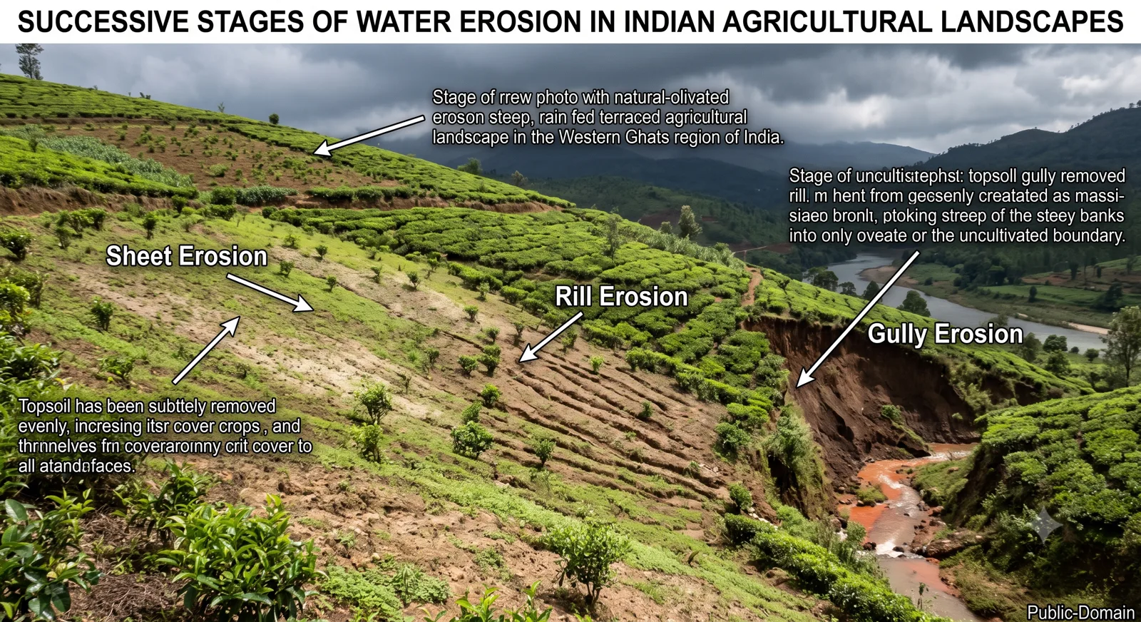
Successive stages of water erosion in Indian agricultural landscapes showing sheet, rill, and gully erosion on terraced hills
Table of Contents
Chapter 1
The Scale and Nature of the Problem
Soil is formed over centuries and can be lost in a single season of heavy rain or strong wind. In a country where more than half the workforce still depends on agriculture and where food security remains a strategic concern, the progressive thinning and degradation of the soil mantle is not a peripheral environmental issue. It is a direct threat to livelihoods, productivity and ecological stability. Soil erosion in India is both widespread and varied in form. Its causes lie in the interaction of steep slopes, intense monsoon rainfall, fragile geological formations and decades of land-use pressure. Its consequences appear as declining crop yields, silted reservoirs, increased flood peaks and the slow advance of wasteland.
This article examines the problem in full. It analyses the natural and human causes, distinguishes the principal types of erosion and their regional distribution, assesses the economic and ecological impacts, and then reviews the full range of conservation methods together with the government schemes designed to implement them. The treatment remains grounded in Indian conditions and in the practical requirements of competitive examination answers.
Estimates prepared by various official agencies over the years have consistently shown that a large percentage of India’s geographical area is affected by one or another form of degradation. Water erosion dominates in the humid and sub-humid regions; wind erosion is significant in the arid and semi-arid northwest; and specialised forms such as stream-bank and coastal erosion affect particular localities. The problem is not new. Colonial records already noted the expansion of ravines in the Chambal basin and the progressive desiccation of parts of Rajasthan. What has changed is the intensity of human pressure—population growth, expansion of cultivation onto marginal lands, deforestation in the hills, and the mechanical disturbance of soil by mining and construction.
Soil is a non-renewable resource on any human timescale. Once the topsoil is removed, the remaining subsoil is usually poorer in organic matter, less able to hold water, and less responsive to fertiliser. Recovery, where it is possible at all, takes decades. Prevention and control are therefore far more effective than later attempts at restoration.
Chapter 2
Causes of Soil Erosion in India
Natural factors create the predisposition; human activities usually determine the severity.
Topography and climate set the background. The Himalayan and the Western and Eastern Ghats slopes, the ravine-prone alluvial tracts of the Chambal and Yamuna, and the undulating Deccan plateau all offer conditions in which water can acquire high erosive velocity. The monsoon rainfall regime—long dry periods followed by intense downpours—further increases the risk. When the soil surface is bare at the onset of the rains, the first storms detach and transport large quantities of material.
Human causes amplify these natural tendencies. Deforestation and the removal of vegetative cover deprive the soil of the protective canopy and root binding that intercept rainfall and slow runoff. Overgrazing, especially in the arid and semi-arid zones, reduces grass cover and compacts the soil. Faulty agricultural practices—cultivation up and down the slope, lack of cover crops, excessive tillage, and the extension of cropping onto steep or marginal lands—expose the soil to direct impact. Mining, road cutting and urban construction create fresh surfaces that erode rapidly until stabilised. In irrigated areas, improper water management can lead to waterlogging and secondary salinisation, which further degrade soil structure and make it more vulnerable to erosion when water eventually moves.
The relative weight of these factors varies by region. In the Himalayas the combination of steep slopes, seismic fragility, heavy rainfall and deforestation is decisive. In Rajasthan wind and the sparse vegetation of the arid zone dominate. In the black-soil regions of the Deccan, intense rainfall on cracking clay soils produces rapid gully formation once the protective cover is lost.
Chapter 3
Types of Soil Erosion and Regional Patterns
Water erosion is the most extensive. It begins as sheet erosion—the uniform removal of thin layers of topsoil—which is often unnoticed until productivity declines. Concentrated flow produces rills and, with further deepening, gullies. In extreme cases, as in the Chambal–Yamuna ravine zone, a dense network of gullies converts productive land into badlands. Stream-bank erosion undercuts river margins during high flows, while coastal erosion affects parts of the eastern and western seaboards through wave action and tidal currents.
Wind erosion is characteristic of the arid and semi-arid tracts of Rajasthan, parts of Gujarat, Haryana and southern Punjab. Sand particles move by saltation, finer material enters suspension, and coarser grains creep along the surface. The result is the loss of fertile fines, the burial of productive land under shifting sand, and the degradation of both agricultural and grazing areas.
Mass-movement forms such as landslides and soil creep are important in the Himalayan and Western Ghat regions, especially where slopes have been undercut by roads or stripped of forest. Coastal and river-bank erosion complete the inventory.
Chapter 4
Impacts on Agriculture, Economy and Ecology
The most immediate impact is the decline in soil fertility and water-holding capacity. Farmers respond with higher doses of fertiliser, raising costs and often creating nutrient imbalances. Reservoirs and irrigation canals silt up, reducing their useful life and the reliability of water supply. Flood peaks increase because degraded catchments release water more rapidly. Downstream, the same sediment that is lost from the hills chokes river channels and can raise riverbeds.
At the national level the cumulative loss of productive capacity has implications for food security and for the economic viability of rain-fed farming, which still covers a large share of cultivated area. Ecologically, erosion reduces biodiversity, damages aquatic habitats through sedimentation, and contributes to the spread of wasteland. In the drylands it accelerates the processes that lead toward desertification.
Prepare for UPSC with Best Resources
Get exclusive study material and regular updates directly on your phone.
Join @RRBCONTENTS on Telegram →Chapter 5
Conservation Methods: Principles and Practices
Effective conservation rests on two principles: protect the soil surface from the direct impact of rain or wind, and slow the movement of water or air so that its energy is reduced.
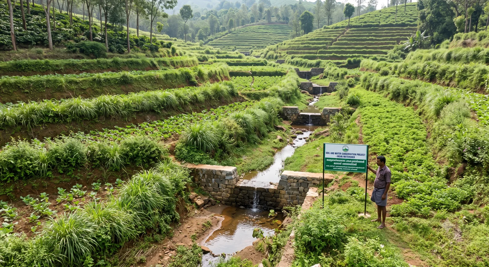
Soil and water conservation project demonstrating check dams and terraced farming on hills to prevent soil erosion
Agronomic measures work with the growing system itself. Contour cultivation and contour bunding align tillage and barriers with the slope, intercepting runoff. Cover crops, mulching and the retention of crop residues keep the surface protected. Crop rotation and intercropping improve soil structure and organic matter. Agroforestry and farm forestry introduce trees that stabilise soil, improve micro-climate and provide additional income. In dry areas shelter belts and windbreaks of suitable species reduce wind velocity at the ground surface.
Mechanical or engineering measures are required where slopes are steep or gullies already exist. Terracing converts a continuous slope into a series of level or near-level steps. Check dams, gully plugs and earthen bunds reduce the velocity of concentrated flow and encourage deposition of sediment. Contour trenches and staggered trenches are widely used in watershed programmes to increase infiltration. In coastal and river-bank situations, vegetative spurs, geotextiles and carefully designed revetments may be necessary.
Biological measures centre on the restoration of vegetative cover—afforestation, regrassing of degraded pastures, and the stabilisation of sand dunes with appropriate species and temporary barriers. In the Himalayas and Western Ghats, strict protection of remaining forest and the promotion of community-based forest management have proved more effective than isolated plantations.
The most successful interventions usually combine these approaches within a watershed framework. Treating a catchment from ridge to valley ensures that upstream conservation reduces the erosive force that would otherwise damage downstream works.
Chapter 6
Government Schemes and Institutional Framework
Soil conservation has been an official concern since the colonial period, but the scale and orientation of programmes have changed substantially since independence.
Early efforts focused on contour bunding and the reclamation of ravine lands. The establishment of soil conservation research and training centres provided a technical base. From the 1970s onward the emphasis shifted toward integrated watershed management. Programmes such as the Drought Prone Areas Programme, the Desert Development Programme and the Integrated Wastelands Development Programme sought to combine soil and water conservation with livelihood support in fragile regions.
In recent decades the approach has become more technology-enabled and farmer-centric. The Soil Health Card scheme provides field-level information on nutrient status and recommends balanced fertilisation, indirectly reducing the pressure that comes from declining natural fertility. The National Mission for Sustainable Agriculture and the watershed components of the Pradhan Mantri Krishi Sinchayee Yojana support micro-irrigation, water harvesting and soil conservation structures. The Mahatma Gandhi National Rural Employment Guarantee Scheme has financed a large volume of earthwork—bunds, trenches, check dams—that contributes directly to conservation. State-level initiatives and externally aided watershed projects have added further layers of activity.
Implementation remains uneven. Technical design, community participation, post-project maintenance and the convergence of different departmental schemes continue to determine success or failure on the ground. Where village institutions have been actively involved and where conservation has been linked to visible gains in water availability or crop yield, results have been more durable.
Chapter 7
Challenges and the Way Forward
Several persistent difficulties limit the effectiveness of current efforts. Fragmentation of land holdings makes coordinated contour treatment difficult. Grazing pressure on common lands often undoes the gains of plantation or regrassing. Climate change is altering rainfall intensity and the frequency of extreme events, increasing the erosive hazard. Finally, the gap between the laboratory or pilot scale and the widespread adoption of practices by millions of small farmers remains wide.
Future progress will depend on stronger integration of soil conservation with agricultural extension, clearer incentives for farmers to maintain structures and vegetative cover, better use of remote sensing and soil information systems for targeting, and continued emphasis on participatory watershed institutions. Soil health must be treated as a core component of agricultural policy rather than as a separate environmental programme.
Chapter 8
Exam Relevance
Soil erosion and conservation appear regularly in both the geography and the environment sections of competitive examinations. Questions test knowledge of causes and types, the regional distribution of different forms of erosion, the principles behind major conservation techniques, and the objectives of government schemes. Map-based questions may ask candidates to identify ravine zones, desert margins or landslide-prone areas. Mains answers that move from causes to impacts to specific, location-appropriate remedies, and that can cite relevant schemes with their core approach, score consistently well. Linking soil conservation to larger themes such as sustainable agriculture, climate adaptation and rural livelihoods adds further analytical depth.
Chapter 9
Closing Perspective
The soil under India’s fields, forests and pastures is a finite foundation. Its erosion is gradual enough to be ignored in the short term and severe enough to undermine long-term productivity and ecological stability. The causes are known, the techniques of control are well established, and a substantial architecture of government programmes exists. What remains is the consistent, location-specific application of those techniques at a scale commensurate with the problem. For a nation that must continue to feed a large population from a limited and already stressed land resource, the conservation of soil is not optional. It is one of the quiet preconditions of durable development.
Chapter 10
Frequently Asked Questions
What are the main causes of soil erosion in India?
Which regions of India are most affected by gully and ravine erosion?
What is the watershed approach to soil conservation?
How does the Soil Health Card scheme help in soil conservation?
Ready for the Real Test?
Strengthen your preparation with full-length FREE mock tests, previous year questions, and daily study notes.
Start Free Mock Tests →Continue on RRBCONTENTS
Explore More
Knowledge Hub
More Blog Articles
In-depth, exam-focused articles on Indian geography, environment, agriculture and static GK.
Study Material
Exam Study Notes
Subject-wise notes and digests for Railway, SSC, UPSC and State PSC exams.
Current Affairs
Daily Current Affairs & GK
Daily updates and environment & geography topic banks with active-recall quizzes.
"For a nation that must continue to feed a large population from a limited and already stressed land resource, the conservation of soil is not optional. It is one of the quiet preconditions of durable development."