Home › Blog › Geography & Environment › Why Assam Floods Every Year
Why Assam Floods Every Year: Geography & Recent Causes
Key Takeaways & Summary
- Extreme Flood Vulnerability: Approximately 39.58% (31.05 lakh hectares out of 78.52 lakh hectares) of Assam's land area is flood-prone—nearly four times the national average of 10.2%.
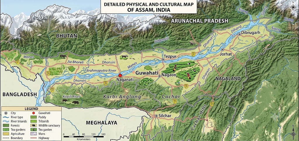
- Geographic Funnel Effect: Enclosed by the Himalayas, Patkai hills, and Meghalaya Plateau, Assam acts as a natural water catchment plain for surrounding high-altitude rainfall.
- Brahmaputra Siltation Crisis: The river carries massive sediment loads from Tibet and Arunachal Pradesh. Silt settles on the valley floor, shallowing the riverbed and causing annual overflow.
- Geological Legacy of 1950: The 8.6 magnitude Assam-Tibet earthquake dumped billions of cubic meters of landslide debris into tributaries, permanently raising riverbed levels.
- Human & Climate Drivers: Outdated 1950s earthen embankments, deforestation in catchment hills, wetland encroachment, and intense short-duration monsoon spells exacerbate flooding.
Table of Contents
- 1. Introduction: The Annual Assam Flood Crisis
- 2. The Geography of Assam: A Natural Catchment Basin
- 3. The Brahmaputra River: A Dynamic Hydrological Giant
- 4. The Legacy of the 1950 Great Assam Earthquake
- 5. Catalysts of Recent Flood Intensification
- 6. Socio-Economic and Ecological Impacts
- 7. Current Management & Sustainable Integrated Strategies
- 8. Exam Relevance & UPSC Syllabus Alignment
1. Introduction: The Annual Assam Flood Crisis
Every year with the arrival of the Southwest Monsoon, the northeastern state of Assam faces severe inundation. Millions of residents are displaced, vast stretches of agricultural land are submerged, and critical infrastructure suffers extensive damage. While seasonal rainfall affects many parts of India, the scale and frequency of the Assam floods remain unique in both magnitude and devastation.
Understanding why floods occur continuously in Assam requires analyzing the state’s complex topography, the behavior of the Brahmaputra River system, and recent environmental changes. Recent disaster data reveals that flooding in Assam has grown more unpredictable and widespread. This comprehensive report examines the geographical factors, hydrological dynamics, human interventions, and climate pressures that turn Assam’s river basins into active flood zones each year.
2. The Geography of Assam: A Natural Catchment Basin
Assam’s geographic location and terrain make it inherently vulnerable to high water accumulation. Situated in the northeastern corner of India, the state primarily consists of two major river valleys: the broad Brahmaputra Valley in the north and the smaller Barak Valley in the south.
The Funnel Topography of the Assam Valley
The Brahmaputra Valley is a narrow plain stretching approximately 720 kilometers in length and 80 to 100 kilometers in width. It is enclosed by high mountain ranges on three sides:
- North: The steep Eastern Himalayas of Arunachal Pradesh and Bhutan.
- East: The Patkai and Purvanchal hill ranges.
- South: The Meghalaya Plateau (including the Garo, Khasi, and Jaintia Hills) and the Karbi Anglong Hills.
This physical layout creates a natural funnel. When heavy monsoonal winds strike the surrounding mountain walls, intense orographic precipitation occurs. All water runoff from the surrounding hills drains directly into the flat plains of Assam.
Extreme Regional Rainfall Metrics
Assam and its neighboring hill states rank among the wettest places on Earth. During the monsoon season from June to September, the region receives an average annual rainfall ranging between 1,500 mm to over 3,000 mm. The runoff from Meghalaya—home to Sohra (Cherrapunji) and Mawsynram—drains swiftly into the Barak Valley and lower Assam plains, causing rapid water-level spikes in local river networks.
3. The Brahmaputra River: A Dynamic Hydrological Giant
At the heart of Assam’s flood crisis lies the Brahmaputra River, one of the largest and most dynamic river systems in Asia. Originating from the Angsi Glacier in Tibet (where it is known as the Yarlung Tsangpo), the river flows eastward for nearly 1,700 kilometers across the Tibetan Plateau before making an abrupt turn around Mount Namcha Barwa.
| Region | Local River Name | Terrain / Velocity Characteristic |
|---|---|---|
| Tibet (China) | Yarlung Tsangpo | High Altitude, Cold Desert, Steep Gradient |
| Arunachal Pradesh | Siang / Dihang | Deep Gorges, High-Velocity Torrent |
| Assam Plains | Brahmaputra | Flat Valley, Silt Deposition, Braided Channel |
| Bangladesh | Jamuna | Low Deltaic Plain, Bay of Bengal Outlet |
High Sediment Load and Shallow Riverbeds
As the river descends rapidly through the deep gorges of Arunachal Pradesh, it carries enormous quantities of topsoil, rocks, and organic debris. The Brahmaputra ranks second globally (behind the Yellow River in China) in terms of sediment transport per unit of drainage area.
When the river enters the flat plains of Assam near Pasighat, its gradient flattens dramatically. The sudden drop in water velocity reduces the river's capacity to transport heavy silt. Consequently, millions of tonnes of sediment settle directly onto the riverbed every year. This continuous siltation raises the riverbed over time. As the channel becomes shallower, its water-carrying capacity decreases. During peak monsoon surges, even moderate rainfall causes the river to overflow its banks.
Braided Channels and River Avulsion
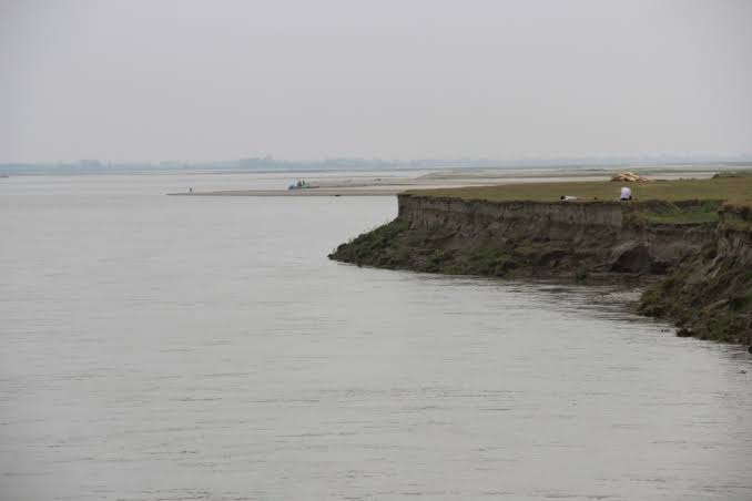
The heavy accumulation of sediment causes the Brahmaputra to form a braided river channel—a complex network of shifting sub-channels, sandbars (chars), and temporary islands. The river frequently undergoes avulsion, a process where it abandons an existing channel to carve an entirely new path through soft alluvial soil. This dynamic shifting renders permanent structural barriers, such as earthen embankments, prone to sudden failure.
A Vast Network of Tributaries
The flood situation in Assam is compounded by the sheer number of rivers feeding into the main channel. More than 50 major tributaries join the Brahmaputra within the Assam Valley alone:
- Northern Tributaries: Subansiri, Jia Bharali, Manas, Beki, Puthimari, and Sankosh. These rivers originate in the steep Himalayas, carrying high water volumes and heavy silt.
- Southern Tributaries: Burhi Dihing, Dhansiri, Kopili, and Krishnai. These rivers carry lower sediment loads but experience sudden flash surges during localized downpours.
When the main stem of the Brahmaputra runs full, it creates a backwater effect, blocking tributary water from discharging smoothly and causing extensive inland flooding.
4. The Legacy of the 1950 Great Assam Earthquake
Geological history plays a direct role in Assam's ongoing vulnerability. On August 15, 1950, a massive magnitude 8.6 earthquake struck the Assam-Tibet border region. It remains one of the most powerful earthquakes recorded in Indian history.
The earthquake destabilized the fragile Himalayan slopes, triggering massive landslides that dumped billions of cubic meters of rock, soil, and forest debris into the Brahmaputra and its northern tributaries. This debris washed down into the valley over subsequent years, causing an unprecedented rise in the riverbed level. Hydrologists note that the river system has never fully recovered its pre-1950 depth and equilibrium, permanently altering Assam's flood dynamics.
Furthermore, Assam lies in Seismic Zone V, the highest earthquake risk category. Minor tremors continuously loosen hillside soil in catchment zones, feeding a steady supply of fresh sediment into the river network.
5. Catalysts of Recent Flood Intensification
While floods are a natural seasonal event in Assam, recent disaster data indicates a sharp escalation in both severity and frequency. In recent years, monsoon cycles have triggered multiple destructive flood waves within a single season, extending into areas previously considered safe.
| Catalyst Factor | Primary Impact on Flood Severity |
|---|---|
| Climate Instability | Short-duration, extreme rainfall cloudbursts & pre-monsoon cyclones |
| Aging Embankments | Structural breaches & sudden high-velocity water surges |
| Deforestation & Hill Cutting | Higher surface runoff & accelerated topsoil erosion in catchment hills |
| Wetlands Encroachment | Loss of natural storm water storage capacity (beels) |
| Transboundary Dam Releases | Unannounced upstream water discharge from upper dams |
1. Climate Change and Altered Rainfall Patterns
Global warming has disrupted traditional monsoon dynamics across Northeast India. Instead of steady, evenly distributed rainfall throughout the four monsoon months, Assam now experiences intense, localized precipitation events.
- Cloudbursts and Intense Spells: Short-duration, high-intensity rain events in upstream catchment regions (such as Arunachal Pradesh, Meghalaya, and Nagaland) push vast amounts of water into tributaries within hours.
- Glacial Melt: Accelerated melting of glaciers in the Tibetan Plateau increases base flows in the Yarlung Tsangpo before it reaches India.
- Pre-Monsoon Flooding: Tropical cyclones originating in the Bay of Bengal (such as Cyclone Remal in May 2024) trigger early flood cycles before the main monsoon arrives.
2. Failure and Degradation of Aging Embankments
Following the catastrophic floods of 1954, the state government launched an extensive program to construct earthen embankments along the Brahmaputra and its tributaries. Over 4,400 kilometers of embankments were built across Assam over the following decades.
- Outlived Lifespans: Over 70% of Assam's embankments have surpassed their structural lifespan of 25 to 30 years.
- Frequent Breaches: According to official records from the Water Resources Department, hundreds of embankment breaches have occurred across Assam over the past decade.
- The Breach Hazard: When an embankment breaks under high water pressure, it releases a sudden, destructive surge of water that sweeps through nearby villages with far greater velocity than a gradual river overflow.
3. Deforestation and Unregulated Hill Cutting
Rapid land-use changes across the northeastern states have accelerated ecological degradation. Large-scale forest clearance for agriculture, infrastructure development, and mining in the catchment hills of Arunachal Pradesh, Meghalaya, and Assam has reduced natural tree cover. Without dense forest canopy and deep root systems to absorb rainfall, rainwater moves rapidly across exposed soil as surface runoff. This runoff washes topsoil directly into river channels, accelerating soil erosion and raising downstream riverbeds even faster.
4. Loss of Natural Wetlands and Sponges
Historically, Assam possessed a vast network of natural wetlands, oxbow lakes (beels), and low-lying floodplains that served as natural buffers during high-water events. Wetlands like Deepor Beel near Guwahati, along with thousands of smaller water bodies across rural districts, absorbed surplus floodwaters and recharged local groundwater tables. Over recent decades, urban expansion, industrial development, agricultural encroachment, and road construction have degraded these natural reservoirs. With natural retention basins lost, excess water spills directly into residential areas and agricultural fields.
6. Socio-Economic and Ecological Impacts
The recurring nature of the floods creates a long-term socio-economic burden on the state.
Human Displacement and Livelihood Losses
According to data from the Rashtriya Barh Ayog (National Flood Commission), approximately 31.05 lakh hectares out of Assam’s total area of 78.52 lakh hectares—nearly 40% of the state's total land area—is classified as flood-prone. This vulnerability rate is nearly four times the national average of 10.2%.
- Mass Displacement: Severe flood years result in millions of internal displacements across dozens of districts.
- Vulnerability of 'Char' Dwellers: Over 10% of Assam’s population lives on the fertile sandbars (chars) within the Brahmaputra River. These communities are exposed to direct channel changes and island erosion.
- Agricultural Destruction: Standing summer crops, particularly Sali paddy, are frequently ruined, forcing farm families into financial distress and debt cycles.
Permanent Land Loss Through Riverbank Erosion
Unlike temporary floodwaters that recede over weeks, riverbank erosion causes permanent land loss. Since 1950, Assam has lost more than 4,200 square kilometers of land—an area larger than the state of Goa—to riverbank erosion along the Brahmaputra and its tributaries. Thousands of families lose their homes and agricultural plots every year, transforming land-owning farmers into displaced, landless laborers.
Impact on Wildlife and Ecosystems
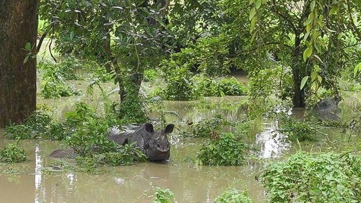
The floods affect Assam’s protected natural reserves, most notably Kaziranga National Park, a UNESCO World Heritage site and home to the world's largest population of the Indian one-horned rhinoceros. While annual flooding is ecologically necessary to maintain Kaziranga's wetland ecosystem, remove invasive vegetation, and replenish fish stocks, extreme flood levels cause significant animal casualties. Wildlife migrating toward the safer Karbi Anglong hills must cross the busy National Highway 715 (formerly NH-37), exposing them to vehicle collisions.
7. Current Management & Sustainable Integrated Strategies
Flood management in Assam has traditionally relied on structural engineering solutions, primarily centered on earthen embankments and riverbank protection walls.
| Traditional Approach (Structural) | Modern Integrated Approach (IRBM) |
|---|---|
| Heavy reliance on earthen dykes & embankments | Scientific sediment & riverbed dredging |
| Emergency breach repairs during peak monsoon | Catchment area afforestation & soil conservation |
| Localized bank revetment and boulder spurs | Wetland rejuvenation & floodplain retention basins |
| Disjointed administrative state-level response | Transboundary river basin coordination & AI forecasting |
1. Scientific Dredging and Sediment Management
Targeted, scientific dredging of high-priority bottlenecks can help restore water-carrying capacity along key stretches of the Brahmaputra. Extracted silt can be processed for infrastructure construction or utilized to strengthen eroded riverbanks.
2. Watershed Reforestation and Upper Catchment Protection
Restoring forest cover across the hills of Arunachal Pradesh, Meghalaya, and Nagaland is essential to slowing surface runoff and stabilizing topsoil. Afforestation programs significantly reduce the volume of sediment entering tributary networks.
3. Rejuvenation of Natural Wetlands and Storage Basins
Restoring degraded water bodies (beels) across Assam provides natural storage zones that temporarily hold floodwaters during peak discharge windows. Enforcing strict laws against encroaching on wetlands protects urban and rural drainage networks.
4. Implementation of Flood Plain Zoning
Enforcing statutory Flood Plain Zoning policies helps restrict high-density residential construction, heavy industrial facilities, and critical infrastructure within high-risk flood zones. Utilizing low-risk zones for seasonal agriculture or recreational green spaces reduces property loss during high-water months.
8. Exam Relevance & UPSC Syllabus Alignment
UPSC & State PSC Study Notes
GS Paper 1 (Geography): Drainage systems of India, Himalayan vs. Peninsular rivers, physical features of Northeast India, riverbank erosion dynamics.
GS Paper 3 (Disaster Management & Environment): Flood control measures, Sendai Framework for Disaster Risk Reduction, Integrated River Basin Management (IRBM), ecological impact on Kaziranga National Park.
Key Fact for Prelims: Assam flood vulnerability (~39.58%) is nearly 4x the national average (10.2%). Brahmaputra ranks 2nd globally in sediment transport per unit area.
Frequently Asked Questions
Why is the Brahmaputra River prone to extreme flooding?
The Brahmaputra carries one of the world's highest sediment loads per unit area. As it enters Assam's flat valley, water velocity drops, causing massive silt deposition that shallow the riverbed and forces water over banks.
What percentage of Assam's geographical area is flood-prone?
Nearly 39.58% (31.05 lakh hectares out of 78.52 lakh hectares) of Assam's total land area is classified as flood-prone, which is almost four times the national average for India (10.2%).
How did the 1950 Great Assam Earthquake affect flood dynamics?
The 8.6 magnitude earthquake triggered massive landslides in the Himalayas, dumping billions of cubic meters of sediment into the river system. The riverbed has never fully recovered its pre-1950 depth.
Sources: Water Resources Department (Govt of Assam), Rashtriya Barh Ayog (National Flood Commission), Central Water Commission (CWC), Ministry of Jal Shakti.
NEEDS DOUBLE-CHECK: none
Prepare for Civil Services & Govt Exams on RRBCONTENTS
Access free geography notes, PYQ solution sets, and current affairs analysis.
Solve Geography PYQs → Explore Govt Jobs →Join our official Telegram channel: @rrbcontents